DRC Reference: Layer Object
- "&" - Boolean AND operation
- "+" - Join layers
- "-" - Boolean NOT operation
- "^" - Boolean XOR operation
- "and" - Boolean AND operation
- "andnot" - Computes Boolean AND and NOT results at the same time
- "area" - Returns the total area of the polygons in the region
- "bbox" - Returns the overall bounding box of the layer
- "centers" - Returns the center parts of the edges
- "clean" - Marks a layer as clean
- "collect" - Transforms a layer
- "collect_to_edge_pairs" - Transforms a layer into edge pair objects
- "collect_to_edges" - Transforms a layer into edge objects
- "collect_to_region" - Transforms a layer into polygon objects
- "corners" - Selects corners of polygons
- "count" - Returns the number of objects on the layer
- "covering" - Selects shapes or regions of self which completely cover (enclose) one or more shapes from the other region
- "data" - Gets the low-level data object
- "drc" - Provides a generic DRC function for use with DRC expressions
- "dup" - Duplicates a layer
- "each" - Iterates over the objects from the layer
- "edge_pairs?" - Returns true, if the layer is an edge pair collection
- "edges" - Decomposes the layer into single edges
- "edges?" - Returns true, if the layer is an edge layer
- "enc" - An alias for "enclosing"
- "enclosed" - An enclosing check (other_layer enclosing layer)
- "enclosing" - An enclosing check (layer enclosing other_layer)
- "end_segments" - Returns the part at the end of each edge
- "evaluate" - Evaluates expressions on the shapes of the layer
- "evaluated" - Evaluates expressions on the shapes of the layer and returns a new layer
- "extended" - Returns polygons describing an area along the edges of the input
- "extended_in" - Returns polygons describing an area along the edges of the input
- "extended_out" - Returns polygons describing an area along the edges of the input
- "extent_refs" - Returns partial references to the boundings boxes of the polygons
- "extents" - Returns the bounding box of each input object
- "fill" - Fills the region with regular pattern of shapes
- "fill_with_left" - Fills the region with regular pattern of shapes
- "first_edges" - Returns the first edges of an edge pair collection
- "flatten" - Flattens the layer
- "forget" - Cleans up memory for this layer
- "hier_count" - Returns the hierarchical number of objects on the layer
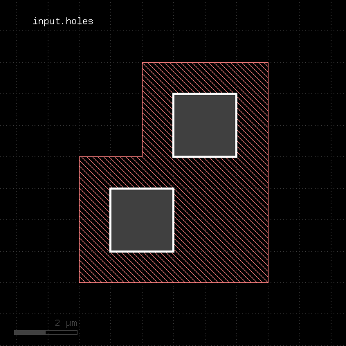
- "holes" - Selects all polygon holes from the input
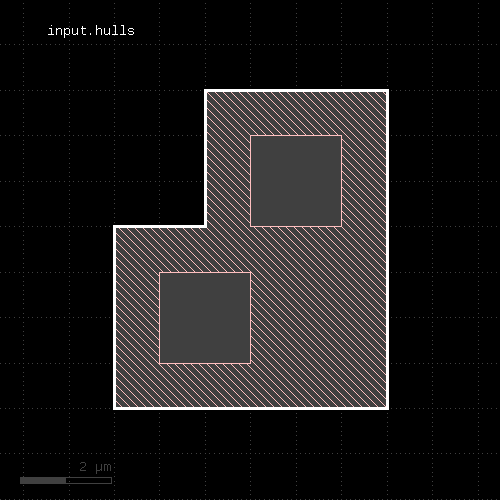
- "hulls" - Selects all polygon hulls from the input
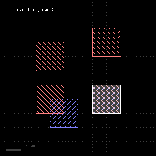
- "in" - Selects shapes or regions of self which are contained in the other layer
- "in_and_out" - Selects shapes or regions of self which are and which are not contained in the other layer
- "insert" - Inserts one or many objects into the layer
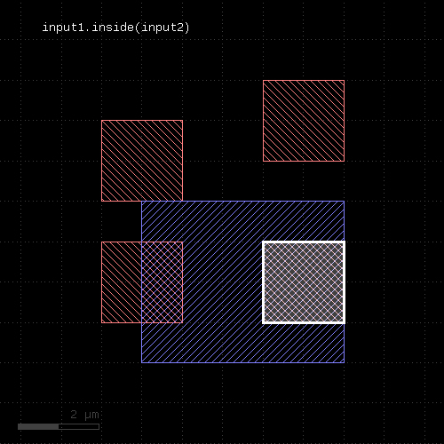
- "inside" - Selects edges, edge pairs or polygons of self which are inside edges or polygons from the other layer
- "inside_outside_part" - Returns the parts of the edges inside and outside the given region
- "inside_part" - Returns the parts of the edges inside the given region
- "interacting" - Selects shapes or regions of self which touch or overlap shapes from the other region
- "intersections" - Returns the intersection points of intersecting edge segments for two edge collections
- "is_box?" - Returns true, if the region contains a single box
- "is_clean?" - Returns true, if the layer is clean state
- "is_deep?" - Returns true, if the layer is a deep (hierarchical) layer
- "is_empty?" - Returns true, if the layer is empty
- "is_merged?" - Returns true, if the polygons of the layer are merged
- "is_raw?" - Returns true, if the layer is raw state
- "iso" - An alias for "isolated"
- "isolated" - An inter-polygon isolation check
- "join" - Joins the layer with another layer
- "length" - Returns the total length of the edges in the edge layer
- "map_props" - Selects properties with certain keys and allows key mapping
- "merge" - Merges the layer (modifies the layer)
- "merge_props" - Merges the layer and joins the properties (modifies the layer)
- "merged" - Returns the merged layer
- "merged_props" - Merges and joins properties of the shapes
- "middle" - Returns the center points of the bounding boxes of the polygons
- "move" - Moves (shifts, translates) a layer (modifies the layer)
- "moved" - Moves (shifts, translates) a layer
- "nets" - Pulls net shapes from selected or all nets, optionally annotating nets with properties
- "non_rectangles" - Selects all polygons from the input which are not rectangles
- "non_rectilinear" - Selects all non-rectilinear polygons from the input
- "non_squares" - Selects all polygons from the input which are not squares
- "non_strict" - Marks a layer for non-strict handling
- "not" - Boolean NOT operation
- "not_covering" - Selects shapes or regions of self which do not cover (enclose) one or more shapes from the other region
- "not_in" - Selects shapes or regions of self which are not contained in the other layer
- "not_inside" - Selects edges, edge pairs or polygons of self which are not inside edges or polygons from the other layer
- "not_interacting" - Selects shapes or regions of self which do not touch or overlap shapes from the other region
- "not_outside" - Selects edges, edge pairs or polygons of self which are not outside edges or polygons from the other layer
- "not_overlapping" - Selects shapes or regions of self which do not overlap shapes from the other region
- "notch" - An intra-polygon spacing check
- "odd_polygons" - Checks for odd polygons (self-overlapping, non-orientable)
- "ongrid" - Checks for on-grid vertices
- "or" - Boolean OR operation
- "output" - Outputs the content of the layer
- "outside" - Selects edges, edge pairs or polygons of self which are outside edges or polygons from the other layer
- "outside_part" - Returns the parts of the edges outside the given region
- "overlap" - An overlap check
- "overlapping" - Selects shapes or regions of self which overlap shapes from the other region
- "perimeter" - Returns the total perimeter of the polygons in the region
- "polygons" - Returns polygons from edge pairs
- "polygons?" - Returns true, if the layer is a polygon layer
- "pull_inside" - Selects shapes or regions of other which are inside polygons from the this region
- "pull_interacting" - Selects shapes or edges of other which touch or overlap shapes from the this region
- "pull_overlapping" - Selects shapes or regions of other which overlap shapes from the this region
- "raw" - Marks a layer as raw
- "rectangles" - Selects all rectangles from the input
- "rectilinear" - Selects all rectilinear polygons from the input
- "remove_props" - Returns a new layer with all properties removed
- "rotate" - Rotates a layer (modifies the layer)
- "rotated" - Rotates a layer
- "rounded_corners" - Applies corner rounding to each corner of the polygon
- "scale" - Scales a layer (modifies the layer)
- "scaled" - Scales a layer
- "second_edges" - Returns the second edges of an edge pair collection
- "select" - Selects edges, edge pairs or polygons based on evaluation of a block
- "select_covering" - Selects shapes or regions of self which completely cover (enclose) one or more shapes from the other region
- "select_if" - Selects shapes of a layer based on the evaluation of an expression
- "select_inside" - Selects edges, edge pairs or polygons of self which are inside edges or polygons from the other layer
- "select_interacting" - Selects shapes or regions of self which touch or overlap shapes from the other region
- "select_not_covering" - Selects shapes or regions of self which do not cover (enclose) one or more shapes from the other region
- "select_not_inside" - Selects edges, edge pairs or polygons of self which are not inside edges or polygons from the other layer
- "select_not_interacting" - Selects shapes or regions of self which do not touch or overlap shapes from the other region
- "select_not_outside" - Selects edges, edge pairs or polygons of self which are not outside edges or polygons from the other layer
- "select_not_overlapping" - Selects shapes or regions of self which do not overlap shapes from the other region
- "select_outside" - Selects edges, edge pairs or polygons of self which are outside edges or polygons from the other layer
- "select_overlapping" - Selects shapes or regions of self which overlap shapes from the other region
- "select_props" - Enables or selects properties from a property-annotated layer
- "selected_if" - Selects shapes based on the evaluation of an expression
- "sep" - An alias for "separation"
- "separation" - A two-layer spacing check
- "size" - Polygon sizing (per-edge biasing, modifies the layer)
- "sized" - Polygon sizing (per-edge biasing)
- "smoothed" - Smoothes the polygons of the region
- "snap" - Brings each vertex on the given grid (g or gx/gy for x or y direction)
- "snapped" - Returns a snapped version of the layer
- "space" - A space check
- "split_covering" - Returns the results of covering and not_covering at the same time
- "split_if" - Selects shapes based on the evaluation of an expression and returns selected and unselected shapes in different layers
- "split_inside" - Returns the results of inside and not_inside at the same time
- "split_interacting" - Returns the results of interacting and not_interacting at the same time
- "split_outside" - Returns the results of outside and not_outside at the same time
- "split_overlapping" - Returns the results of overlapping and not_overlapping at the same time
- "squares" - Selects all squares from the input
- "start_segments" - Returns the part at the beginning of each edge
- "strict" - Marks a layer for strict handling
- "strict?" - Returns true, if strict handling is enabled for this layer
- "texts" - Selects texts from an original layer
- "texts?" - Returns true, if the layer is a text collection
- "texts_not" - Selects texts from an original layer not matching a specific selection
- "transform" - Transforms a layer (modifies the layer)
- "transformed" - Transforms a layer
- "width" - A width check
- "with_angle" - Selects edges by their angle
- "with_area" - Selects polygons or edge pairs by area
- "with_area_ratio" - Selects polygons by the ratio of the bounding box area vs. polygon area
- "with_bbox_aspect_ratio" - Selects polygons by the aspect ratio of their bounding box
- "with_bbox_height" - Selects polygons by the height of the bounding box
- "with_bbox_max" - Selects polygons by the maximum dimension of the bounding box
- "with_bbox_min" - Selects polygons by the minimum dimension of the bounding box
- "with_bbox_width" - Selects polygons by the width of the bounding box
- "with_density" - Returns tiles whose density is within a given range
- "with_distance" - Selects edge pairs by the distance of the edges
- "with_holes" - Selects all polygons with the specified number of holes
- "with_internal_angle" - Selects edge pairs by their internal angle
- "with_length" - Selects edges by their length
- "with_perimeter" - Selects polygons by perimeter
- "with_relative_height" - Selects polygons by the ratio of the height vs. width of its bounding box
- "without_angle" - Selects edges by the their angle
- "without_area" - Selects polygons or edge pairs by area
- "without_area_ratio" - Selects polygons by the aspect ratio of their bounding box
- "without_bbox_height" - Selects polygons by the aspect ratio of their bounding box
- "without_bbox_max" - Selects polygons by the maximum dimension of the bounding box
- "without_bbox_min" - Selects polygons by the minimum dimension of the bounding box
- "without_bbox_width" - Selects polygons by the width of the bounding box
- "without_density" - Returns tiles whose density is not within a given range
- "without_distance" - Selects edge pairs by the distance of the edges
- "without_holes" - Selects all polygons with the specified number of holes
- "without_internal_angle" - Selects edge pairs by their internal angle
- "without_length" - Selects edges by the their length
- "without_perimeter" - Selects polygons by perimeter
- "without_relative_height" - Selects polygons by the ratio of the height vs. width
- "xor" - Boolean XOR operation
- "|" - Boolean OR operation
"&" - Boolean AND operation
Usage:
- self & other
The method computes a boolean AND between self and other.
This method is available for polygon and edge layers. An alias is "and". See there for a description of the function.
"+" - Join layers
Usage:
- self + other
The method includes the edges or polygons from the other layer into this layer. The "+" operator is an alias for the join method.
This method is available for polygon, edge and edge pair layers. An alias is "join". See there for a description of the function.
"-" - Boolean NOT operation
Usage:
- self - other
The method computes a boolean NOT between self and other.
This method is available for polygon and edge layers. An alias is "not". See there for a description of the function.
"^" - Boolean XOR operation
Usage:
- self ^ other
The method computes a boolean XOR between self and other.
This method is available for polygon and edge layers. An alias is "xor". See there for a description of the function.
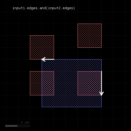
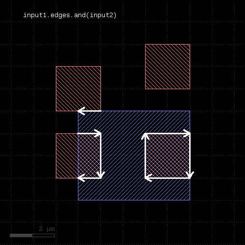
"and" - Boolean AND operation
Usage:
- layer.and(other [, prop_constraint ])
The method computes a boolean AND between self and other. It is an alias for the "&" operator which lacks the ability to specify a properties constraint.
This method is available for polygon and edge layers. If the first operand is an edge layer and the second is a polygon layer, the result will be the edges of the first operand which are inside or on the borders of the polygons of the second operand.
The following images show the effect of the "and" method on polygons and edges (input1: red, input2: blue):
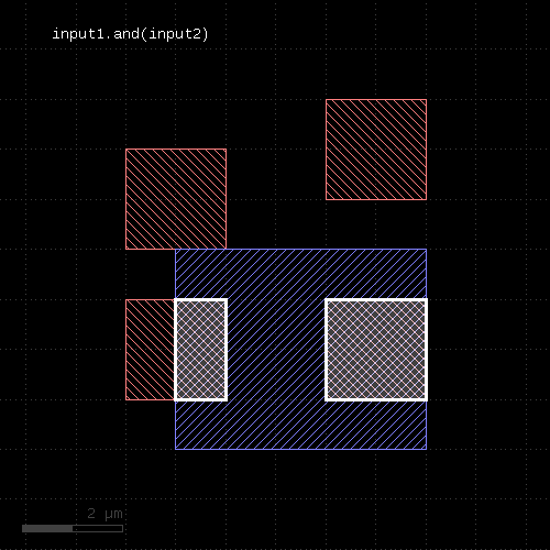 |  |  |
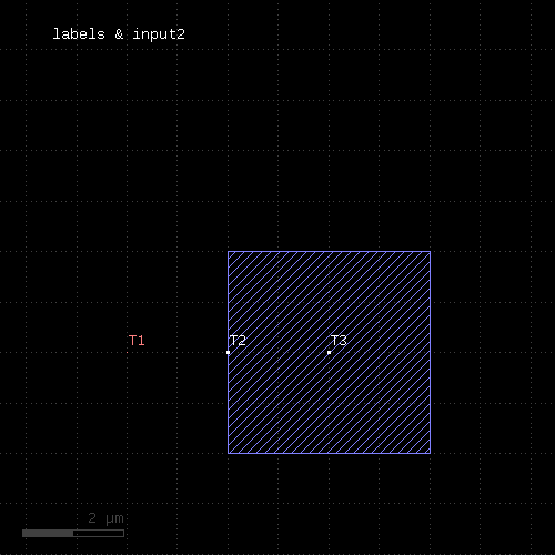
The AND operation can be applied between a text and a polygon layer. In this case, the texts inside or at the border of the polygons will be written to the output (labels: red, input2: blue):
 |
When a properties constraint is given, the operation is performed only between shapes with the given relation. Together with the ability to provide net-annotated shapes through the nets method, this allows constraining the boolean operation to shapes from the same or from different nets.
See prop_eq, prop_ne and prop_copy for details.
"andnot" - Computes Boolean AND and NOT results at the same time
Usage:
- layer.andnot(other)
This method returns a two-element array containing one layer for the AND result and one for the NOT result.
This method is available for polygon and edge layers. For polygon layers, the other input must be a polygon layer too. For edge layers, the other input can be polygon or edge.
It can be used to initialize two variables with the AND and NOT results:
(and_result, not_result) = l1.andnot(l2)
As the AND and NOT results are computed in the same sweep, calling this method is faster than calling AND and NOT separately.
"area" - Returns the total area of the polygons in the region
Usage:
- layer.area
This method requires a polygon layer. It returns the total area of all polygons in square micron. Merged semantics applies, i.e. before computing the area, the polygons are merged unless raw mode is chosen (see raw). Hence, in clean mode, overlapping polygons are not counted twice.
The returned value gives the area in square micrometer units.
"bbox" - Returns the overall bounding box of the layer
Usage:
- layer.bbox
The return value is a DBox object giving the bounding box in micrometer units.
"centers" - Returns the center parts of the edges
Usage:
- layer.centers(length)
- layer.centers(length, fraction)
Similar to start_segments and end_segments, this method will return partial edges for each given edge in the input. For the description of the parameters see start_segments or end_segments.
The following images show the effect of the method:
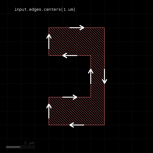 | 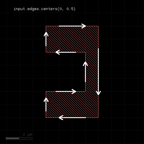 |
"clean" - Marks a layer as clean
Usage:
- layer.clean
A layer marked as clean will provide "merged" semantics, i.e. overlapping or touching polygons are considered as single polygons. Inner edges are removed and collinear edges are connected. Clean state is the default.
See raw for some remarks about how this state is propagated.
"collect" - Transforms a layer
Usage:
- layer.collect { |object| ... }
This method evaluates the block for each object in the layer and returns a new layer with the objects returned from the block. It is available for edge, polygon and edge pair layers. The corresponding objects are DPolygon, DEdge or DEdgePair.
If the block evaluates to nil, no object is added to the output layer. If it returns an array, each of the objects in the array is added. The returned layer is of the original type and will only accept objects of the respective type. Hence, for polygon layers, DPolygon objects need to be returned. For edge layers those need to be DEdge and for edge pair layers, they need to be DEdgePair objects. For convenience, Polygon, Edge and EdgePair objects are accepted too and are scaled by the database unit to render micrometer-unit objects. Region, Edges and EdgePair objects are accepted as well and the corresponding content of that collections is inserted into the output layer.
Other versions are available that allow translation of objects into other types (collect_to_region, collect_to_edges and collect_to_edge_pairs).
Because this method executes inside the interpreter, it's inherently slow. Tiling does not apply to this method.
Here is a slow equivalent of the rotated method
# Rotates by 45 degree
t = DCplxTrans(1.0, 45.0, false, DVector::new)
new_layer = layer.collect { |polygon| polygon.transformed(t) }
"collect_to_edge_pairs" - Transforms a layer into edge pair objects
Usage:
- layer.collect_to_edge_pairs { |object| ... }
This method is similar to collect, but creates an edge pair layer. It expects the block to deliver EdgePair, DEdgePair or EdgePairs objects.
"collect_to_edges" - Transforms a layer into edge objects
Usage:
- layer.collect_to_edges { |object| ... }
This method is similar to collect, but creates an edge layer. It expects the block to deliver objects that can be converted into edges. If polygon-like objects are returned, their contours will be turned into edge sequences.
"collect_to_region" - Transforms a layer into polygon objects
Usage:
- layer.collect_to_region { |object| ... }
This method is similar to collect, but creates a polygon layer. It expects the block to deliver objects that can be converted into polygons. Such objects are of class DPolygon, DBox, DPath, Polygon, Path, Box and Region.
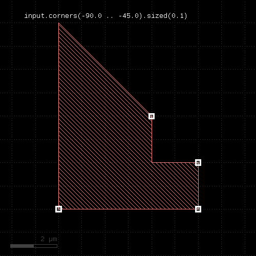
"corners" - Selects corners of polygons
Usage:
- layer.corners([ options ])
- layer.corners(angle [, options ])
- layer.corners(amin .. amax [, options ])
This method produces markers on the corners of the polygons. An angle criterion can be given which selects corners based on the angle of the connecting edges. Positive angles indicate a left turn while negative angles indicate a right turn. Since polygons are oriented clockwise, positive angles indicate concave (inner) corners while negative ones indicate convex (outer) corners The 'absolute' option allows turning this off and considering both left and right turns positive angles.
The markers generated can be point-like edges or small 2x2 DBU boxes. The latter is the default.
The options available are:
- as_boxes : with this option, small boxes will be produced as markers
- as_dots : with this option, point-like edges will be produced instead of small boxes
- as_edge_pairs : with this option, an edge pair is produced for each corner selected. The first edge is the incoming edge to the corner, the second edge the outgoing edge.
- absolute : with this option, left and right turns will both be considered positive angles
- negative : with this option, all corners not matching the angle criterion are selected
The following images show the effect of this method:
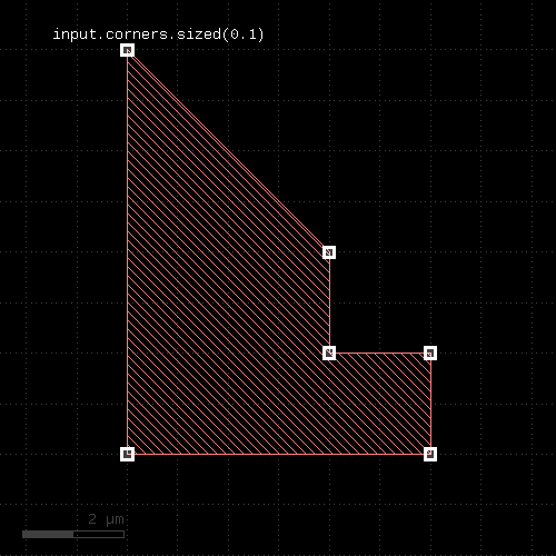 | 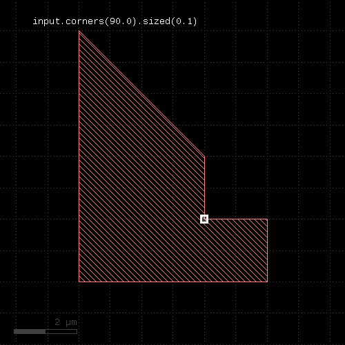 |  |
"count" - Returns the number of objects on the layer
Usage:
- layer.count
The count is the number of raw objects, not merged regions or edges. This is the flat count - the number of polygons, edges or edge pairs seen from the top cell. "count" can be computationally expensive for original layers with clip regions or cell tree filters.
See hier_count for a hierarchical (each cell counts once) count.
"covering" - Selects shapes or regions of self which completely cover (enclose) one or more shapes from the other region
Usage:
- layer.covering(other)
- layer.covering(other, min_count)
- layer.covering(other, min_count, max_count)
- layer.covering(other, min_count .. max_count)
This method selects all shapes or regions from self which completly cover shapes from the other region. Unless self is in raw mode (see raw), coherent regions are selected from self, otherwise individual shapes are selected. It returns a new layer containing the selected shapes. A version which modifies self is select_covering.
This method is available for polygons only.
The following image shows the effect of the "covering" method:
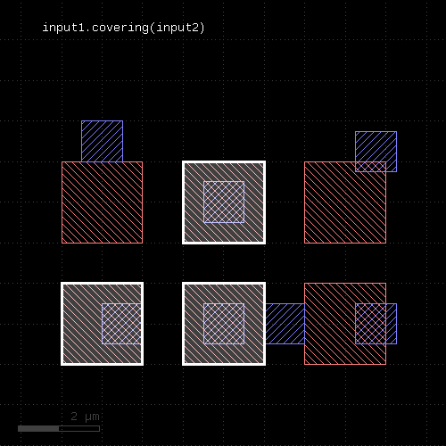 |
A range of counts can be specified. If so, the shape from the primary layer is only selected when covering a given number of shapes from the other layer. For the interpretation of the count see interacting.
The "covering" attribute is sometimes called "enclosing", but this name is used for the respective DRC function (see enclosing).
"data" - Gets the low-level data object
Usage:
- layer.data
This method returns a Region, Edges or EdgePairs object representing the underlying RBA object for the data. Access to these objects is provided to support low-level iteration and manipulation of the layer's data.
"drc" - Provides a generic DRC function for use with DRC expressions
Usage:
- layer.drc(expression [, prop_constraint ])
This method implements the universal DRC which offers enhanced abilities, improved performance in some applications and better readability.
The key concept for this method are DRC expressions. DRC expressions are formed by using predefined keywords like "width", operators like "&" and methods to build an abstract definition of the operations to perform within the DRC.
When the DRC function is executed, it will basically visit all shapes from the input layer (the layer, the "drc" method is called on)). While it does, it collects the neighbor shapes from all involved other inputs and runs the requested operations on each cluster. Currently, "drc" is only available for polygon layers.
This way, the nature of the "drc" operation is that of the loop over all (merged) input polygons. Within the operation executed on each shape, it's possible to make decisions such as "if the shape has an area larger than something, apply this operation" or similar. This often can be achieved with conventional DRC functions too, but involves potentially complex and heavy operations such as booleans, interact etc. For this reason, the "drc" function may provide a better performance.
In addition, within the loop a single shape from the input layer is presented to the execution engine which runs the operations. This allows using operations such as "size" without having to consider neighbor polygons growing into the area of the initial shape. In this sense, the "drc" function sees the layer as individual polygons rather than a global "sea of polygons". This enables new applications which are otherwise difficult to implement.
Primaries and secondaries
An important concept in "drc" expressions is the "primary". The primary represents a single shape from the input layer. "Secondaries" are shapes from other inputs. Primaries guide the operation - secondaries without primaries are not seen. The "drc" operation will look for secondaries within a certain distance which is determined from the operations from the expression to execute. The secondaries collected in this step will not be merged, so the secondary polygons may be partial. This is important when using measurement operations like "area" on secondary polygons.
Checks
Here is an example for a generic DRC operation which performs a width check for less than 0.5.um on the primary shapes. It uses the "width" operator:
out = in.drc(width < 0.5.um)
Other single or double-bounded conditions are available too, for example:
out = in.drc(width <= 0.5.um)
out = in.drc(width > 0.5.um)
out = in.drc(width == 0.5.um)
out = in.drc(width != 0.5.um)
out = in.drc(0.2.um < width < 0.5.um)
To specify the second input for a two-layer check, add it to the check function. This example shows how to use a two-layer separation check ("separation"):
l1 = input(1, 0)
l2 = input(2, 0)
out = l1.drc(separation(l2) < 0.5.um)
The second input of this check function can be a computed expression. In this case the local loop will first evaluate the expression for the second input and then use the result as second input in the check. Note that this computation is performed locally and separately for each primary and its context.
Options for the checks are also specified inside the brackets. For example, to select projection metrics ("projection") for the "width" check use:
out = in.drc(width(projection) < 0.5.um)
Edges and edge pairs
Although the "drc" function operates on polygon layers, internally it is able to handle edge and edge pair types too. Some operations generate edge pairs, some other generate edges. As results from one operation can be processed further in the DRC expressions, methods are available to filter, process and convert these types.
For example, all checks produce edge pairs which can be converted into polygons using the "polygons" method:
out = in.drc((width(projection) < 0.5.um).polygons)
Note a subtle detail: when putting the "polygons" method inside the "drc" brackets, it is executed locally on every visited primary polygon. The result in this case is identical to the global conversion:
# same, but with "global" conversion:
out = in.drc(width(projection) < 0.5.um).polygons
But having the check polygons inside the loop opens new opportunities and is more efficient in general. In the previous example, the local conversion will keep a few edge pairs after having converted them to polygons. In the global case, all edge pairs are collected first and then converted. If there are many edge pairs, this requires more memory and a larger computing overhead for managing the bigger number of shapes.
For the conversion of edges, edge pairs and polygons into other types, these methods are provided:
- "DRC#polygons": converts edge pairs to polygons
- "DRC#extended", "DRC#extended_in", "DRC#extended_out": converts edges to polygons
- "DRC#first_edges", DRC#second_edges": extracts edges from edge pairs
- "DRC#edges": decomposes edge pairs and polygons into edges
- "DRC#corners": can extract corners from polygons
The following example decomposes the primary polygons into edges:
out = in.drc(primary.edges)
(for backward compatibility you cannot abbreviate "primary.edges" simply as "edges" like other functions).
The previous example isn't quite exciting as it is equivalent to
# Same as above
out = in.edges
But it gets more interesting, as within the loop, "edges" delivers the edge set for each individual polygon. It's possible to work with this distinct set, so for example this will give you the edges of polygons with more than four corners:
out = in.drc(primary.edges.count > 4)
Explanation: "count" is a "quantifier" which takes any kind of set (edges, edge pairs, polygons) and returns the set if the number of inhabitants meets the given condition. Otherwise the set is skipped. So it will look at the edges and if there are more than four (per primary shape), it will forward this set.
The same result can be achieved with classic DRC with "interact" and a figure count, but at a much higher computation cost.
Edge and edge/polygon operations
The "drc" framework supports the following edge and edge/polygon operations:
- Edge vs. edge and edge vs. polygon booleans
- Edge vs. polygon interactions ("DRC#interacting", "DRC#overlapping")
- Edge sampling ("DRC#start_segments", "DRC#centers", "DRC#end_segments")
Filters
Filter operators select input polygons or edges based on their properties. These filters are provided:
- "DRC#area": selects polygons based on their area
- "DRC#perimeter": selects polygons based on their perimeter
- "DRC#area_ratio": selects polygons based on their bounding box to polygon area ratio
- "DRC#bbox_aspect_ratio": selects polygons based on their bounding box aspect ratio
- "DRC#relative_height": selects polygons based on their relative height
- "DRC#bbox_min", "DRC#bbox_max", "DRC#bbox_width", "DRC#bbox_height": selects polygons based on their bounding box properties
- "DRC#length": selects edges based on their length
- "DRC#angle": selects edges based on their orientation
For example, to select polygons with an area larger than one square micrometer, use:
out = in.drc(area > 1.0)
For the condition, use the usual numerical bounds like:
out = in.drc(area == 1.0)
out = in.drc(area <= 1.0)
out = in.drc(0.2 < area < 1.0)
The result of the area operation is the input polygon if the area condition is met.
In the same fashion, "perimeter" applies to the perimeter of the polygon. "bbox_min" etc. will evaluate a particular dimensions of the polygon's bounding box and use the respective dimension for filtering the polygon.
Note that it's basically possible to use the polygon filters on any input - computed and secondaries. In fact, plain "area" for example is a shortcut for "primary.area" indicating that the area of primary shapes are supposed to be computed. However, any input other than the primary is not necessarily complete or it may consist of multiple polygons. Hence the computed values may be too big or too small. It's recommended therefore to use the measurement functions on primary polygons unless you know what you're doing.
Filter predicates
The "drc" feature also supports some predicates. "predicates" are boolean values indicating a certain condition. A predicate filter works in a way that it only passes the polygons if the condition is met.
The predicates available currently are:
- "DRC#rectangles": Filters rectangles
- "DRC#squares": Filters squares
- "DRC#rectilinear": Filters rectilinear ("Manhattan") polygons
For the same reason as explained above, it's recommended to use these predicates standalone, so they act on primary shapes. It's possible to use the predicates on computed shapes or secondaries, but that may not render the desired results.
Logical NOT operator
The "!" operator will evaluate the expression behind it and return the current primary shape if the input is empty and return an empty polygon set if not. Hence the following filter will deliver all polygons which are not rectangles:
out = in.drc(! rectangles)
Logical combination operators
The logical "if_any" or "if_all" functions allow connecting multiple conditions and evaluate to "true" (means: a non-empty shape set) if either one input is a non-empty shape set ("if_any") or if all inputs are non-empty ("if_all").
For example, this will select all polygons which are rectangles and whose area is larger than 20 square micrometers:
out = in.drc(if_all(rectangles, area > 20.0))
"if_all" delivers the primary shape if all of the input expressions render a non-empty result.
In contrast to this, the "if_any" operation will deliver the primary shape if one of the input expressions renders a non-empty result.
The "switch" function allows selecting one input based on the results of an expression. In the two-input form it's equivalent to "if". The first expression is the condition. If it evaluates to a non-empty shape set, the result of the second expression is taken. Otherwise, the result is empty.
Hence the following code delivers all rectangles sized by 100 nm. All other shapes are skipped:
out = in.drc(switch(rectangles, primary.sized(100.nm)))
A third expression will be considered the "else" branch: the result of this expression will be taken if the first one is not taken. So this example will size all rectangles and leave other shapes untouched:
out = in.drc(switch(rectangles, primary.sized(100.nm), primary))
If more expressions are given, they are considered as a sequence of condition/result chain (c1, e1, c2, e2, ...) in the sense of "if(c1) return(e1) else if(c2) return(e2) ...". So the e1 is taken if c1 is met, e2 is taken when c1 is not met, but c2 is and so forth. If there is an odd number of expressions, the last one will be the default expression which is taken if none of the conditions is met.
Polygon manipulations
The "drc" operations feature polygon manipulations where the input is either the primary, secondaries or derived shapes. Manipulations include sizing ("sized"), corner rounding ("rounded_corners"), smoothing ("smoothed") and boolean operations.
This example computes a boolean AND between two layers before selecting the result polygons with an area larger than 1 square micrometer. Note that "primary" is a placeholder for the primary shape:
l1 = input(1, 0)
l2 = input(2, 0)
out = l1.drc((primary & l2).area > 1.0)
This example demonstrates how the "drc" operation can improve performance: as the boolean operation is computed locally and the result is discarded when no longer required, less shapes need to be stored hence reducing the memory overhead and CPU time required to manage these shapes.
Note that the precise form of the example above is
out = l1.drc((primary & secondary(l2)).area > 1.0)
The "secondary" operator indicates that "l2" is to be used as secondary input to the "drc" function. Only in this form, the operators of the boolean AND can be reversed:
out = l1.drc((secondary(l2) & primary).area > 1.0)
Quantifiers
Some filters operate on properties of the full, local, per-primary shape set. While the loop is executed, the DRC expressions will collect shapes, either from the primary, its neighborhood (secondaries) or from deriving shape sets.
Obviously the primary is a simple one: it consists of a single shape, because this is how the loop operates. Derived shape sets however can be more complex. "Quantifiers" allow assessing properties of the complete, per-primary shape set. A simple one is "DRC#count" which checks if the number of shapes within a shape set is within a given range.
Obviously, "primary.count == 1" is always true. So using "count" primaries isn't much fun. So it's better to use it on derived sets. The following condition will select all primary shapes which have more than 13 corners:
out = in.drc(if_any(primary.corners.count > 13))
Note an important detail here: the "if_any" function will make this statement render primary polygons, if the expression inside gives a non-empty result. Without "if_any", the result would be the output of "count" which is the set of all corners where the corner count is larger than 13.
Expressions as objects
The expression inside the "drc" function is a Ruby object and can be stored in variables. If you need the same expression multiple times, it can be more efficient to use the same Ruby object. In this example, the same expression is used two times. Hence it's computed two times:
out = l1.drc(((primary & l2).area == 1.0) + ((primary & l2).area == 2.0))
A more efficient version is:
overlap_area = (primary & l2).area
out = l1.drc((overlap_area == 1.0) + (overlap_area == 2.0))
Note that the first line prepares the operation, but does not execute the area computation or the boolean operation. But when the "drc" function executes the loop over the primaries it will only compute the area once per primary as it is represented by the same Ruby object.
Properties constraints
The method can be given a properties constraint so that it is only performed between shapes with the same or different user properties. Note that properties have to be enabled or generated (e.g. through the DRCLayer#nets method) before they can be used.
Example:
connect(metal1, via1)
...

space_not_connected = metal1.nets.drc(space < 0.4.um, props_ne)
See props_eq, props_ne and props_copy for details.
Outlook
DRC expressions are quite rich and powerful. They provide a more intuitive way of writing DRC expressions, are more efficient and open new opportunities. DRC development is likely to focus on this scheme in the future.
More formal details about the bits and pieces can be found in the "DRC" class documentation.
"dup" - Duplicates a layer
Usage:
- layer.dup
Duplicates the layer. This basically will create a copy and modifications of the original layer will not affect the duplicate. Please note that just assigning the layer to another variable will not create a copy but rather a pointer to the original layer. Hence modifications will then be visible on the original and derived layer. Using the dup method will avoid that.
However, dup will double the memory required to hold the data and performing the deep copy may be expensive in terms of CPU time.
"each" - Iterates over the objects from the layer
Usage:
- layer.each { |object| ... }
This method evaluates the block on each object of the layer. Depending on the layer type, these objects are of DPolygon, DEdge or DEdgePair type.
Because this method executes inside the interpreter, it's inherently slow. Tiling does not apply to this method.
"edge_pairs?" - Returns true, if the layer is an edge pair collection
Usage:
- layer.edge_pairs?
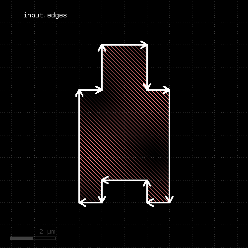
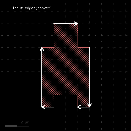
"edges" - Decomposes the layer into single edges
Usage:
- layer.edges
- layer.edges(mode)
Edge pair collections are decomposed into the individual edges that make up the edge pairs. Polygon layers are decomposed into the edges making up the polygons. This method returns an edge layer but will not modify the layer it is called on.
Merged semantics applies, i.e. the result reflects merged polygons rather than individual ones unless raw mode is chosen.
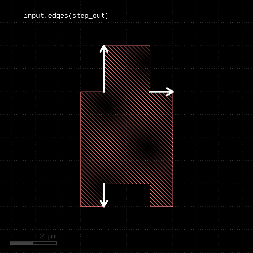
The "mode" argument allows selecting specific edges from polygons. Allowed values are: "convex", "concave", "step", "step_in" and "step_out". "step" generates edges only if they provide a step between two other edges. "step_in" creates edges that make a step towards the inside of the polygon and "step_out" creates edges that make a step towards the outside:
out = in.edges(convex)
In addition, "not_.." variants are available which selects edges not qualifying for the specific mode:
out = in.edges(not_convex)
The mode argument is only available for polygon layers.
The following images show the effect of the mode argument:
 |  |
 |  |
 |  |
"edges?" - Returns true, if the layer is an edge layer
Usage:
- layer.edges?
"enc" - An alias for "enclosing"
Usage:
- layer.enc(value [, options])
See enclosing for a description of that method
"enclosed" - An enclosing check (other_layer enclosing layer)
Usage:
- layer.enclosed(other_layer, value [, options])
Note: "enclosed" is available as operators for the "universal DRC" function drc within the DRC framework. These variants have more options and are more intuitive to use. See enclosed for more details.
This method checks whether layer is enclosed by (is inside of) other_layer by not less than the given distance value. Locations, where the distance is less will be reported in form of edge pair error markers. Locations, where both edges coincide will be reported as errors as well. Formally such locations form an enclosure with a distance of 0. Locations, where other_layer is inside layer will not be reported as errors. Such regions can be detected by inside or a boolean "not" operation.
The options are the same as for separation.
This method is available for edge and polygon layers.
As for the other DRC methods, merged semantics applies.
Distance values can be given as floating-point values (in micron) or integer values (in database units). To explicitly specify the unit, use the unit denominators.
The following images show the effect of two enclosed checks (red: input1, blue: input2):
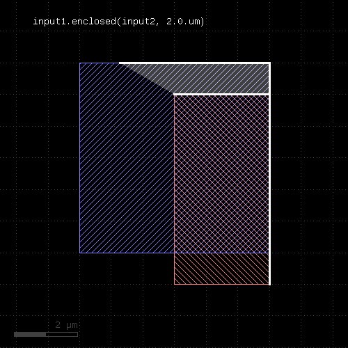 | 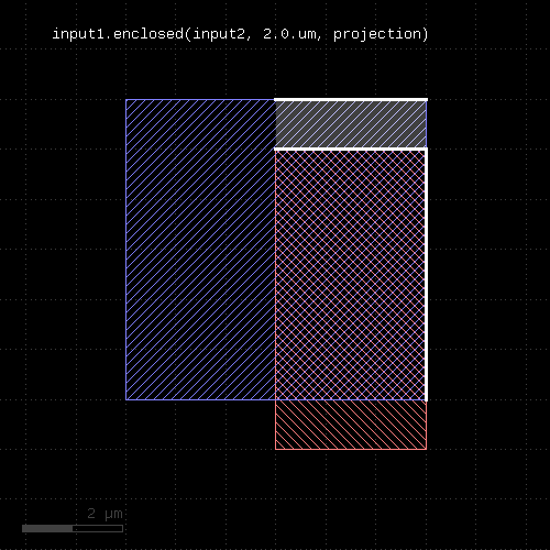 |
"enclosing" - An enclosing check (layer enclosing other_layer)
Usage:
- layer.enclosing(other_layer, value [, options])
- layer.enc(other_layer, value [, options])
Note: "enclosing" and "enc" are available as operators for the "universal DRC" function drc within the DRC framework. These variants have more options and are more intuitive to use. See enclosing for more details.
This method checks whether layer encloses (is bigger than) other_layer by not less than the given distance value. Locations, where the distance is less will be reported in form of edge pair error markers. Locations, where both edges coincide will be reported as errors as well. Formally such locations form an enclosure with a distance of 0. Locations, where other_layer extends outside layer will not be reported as errors. Such regions can be detected by not_inside or a boolean "not" operation.
"enc" is the short form of this method.
The options are the same as for separation.
The enclosing method can be applied to both edge or polygon layers. On edge layers the orientation of the edges matters and only edges looking into the same direction are checked.
As for the other DRC methods, merged semantics applies.
Distance values can be given as floating-point values (in micron) or integer values (in database units). To explicitly specify the unit, use the unit denominators.
The following images show the effect of two enclosing checks (red: input1, blue: input2):
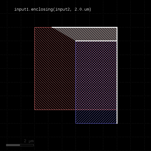 | 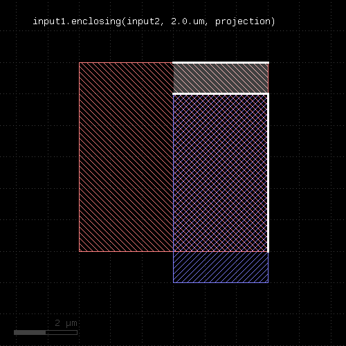 |
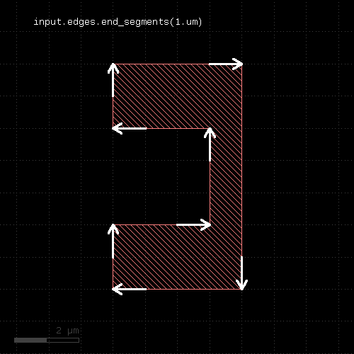
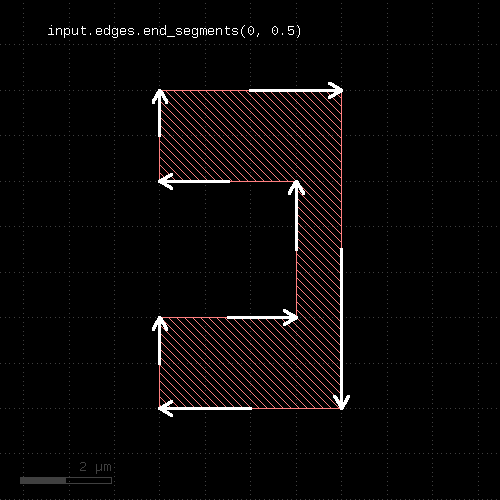
"end_segments" - Returns the part at the end of each edge
Usage:
- layer.end_segments(length)
- layer.end_segments(length, fraction)
This method will return a partial edge for each edge in the input, located and the end of the original edge. The new edges will share the end point with the original edges, but not necessarily their start point. This method applies to edge layers only. The direction of edges is defined by the clockwise orientation of a polygon: the end point of the edges will be the terminal point of each edge when walking a polygon in clockwise direction. Or in other words: when looking from start to the end point of an edge, the filled part of the polygon is to the right.
The length of the new edge can be given in two ways: as a fixed length, or a fraction, or both. In the latter case, the length of the resulting edge will be either the fraction or the fixed length, whichever is larger. To specify a length only, omit the fraction argument or leave it at 0. To specify a fraction only, pass 0 to the length argument and specify the fraction in the second parameter. A fraction of 0.5 will result in edges which cover the end half of the edge.
The following images show the effect of the method:
 |  |
"evaluate" - Evaluates expressions on the shapes of the layer
Usage:
- layer.evaluate(expression [, variables [, keep_properties ]])
Evaluates the given expression on the shapes of the layer. The expression needs to be written in the KLayout expressions notation.
The expressions can place properties on the shapes using the "put" function. As input, the expressions will receive the (merged) shapes in micrometer units (e.g. DPolygon type) by calling the "shape" function.
By default, input shapes are copied to the output with the properties attached to them by "put". You can skip shapes by calling "skip" with a 'true' value. In that case, the shape is not copied. This allows implementing filters.
Available functions for the expressions are:
- "put(name, value)": creates a property with the given name and value
- "skip(flag)": if called with a 'true' value, the shape will be dropped from the output
- "shape": the current shape in micrometer units
- "value(name)": the value of a property with name 'name' or nil if the current shape does not have a property with this name
Properties with well-formed names (e.g. "VALUE") are available as variables in the expressions as a shortcut.
'variables' is a hash of arbitrary names and values. Each of these values becomes available as a variable in the expression. This eliminates the need to build expression strings with pasted value strings for passing external values.
If 'keep_properties' is true, the existing properties of the shape will be kept. Otherwise (the default), existing properties will be removed before adding new ones with 'put'.
The following example computes the area of the shapes and puts them into a property 'area':
layer.evaluate(scales("put('area', shape.area)"))
NOTE: GDS does not support properties with string names, so either save to OASIS or use integer numbers for the property names.
The expressions require a hint whether they make use of anisotropic or scale-dependent properties. For example, the height of a box is an anisotropic property. If a check is made inside a rotated cell, the height transforms to a width and the check renders different results for the same cell, if the cell is placed rotated and non-rotated. The solution is cell variant formation which happens automatically when the "aniso" hint is present.
Similarly, if a check is made against physical dimensions, the check will have different results for cells placed with different magnifications. Such a check is not scale-invariant and needs to get a "scaled" hint.
By default it is assumed that the expressions are isotropic and scale invariant. You can mark an expression as anisotropic and/or scale dependent using the following expression modifiers:
# isotropic and scale invariant
layer.evaluate("put('holes', shape.holes)")

# anisotropic, but scale invariant
layer.evaluate(aniso("put('aspect_ratio', shape.bbox.height/shape.bbox.width)"))

# isotropic, but not scale invariant
layer.evaluate(scales("put('area', shape.area)"))

# anisotropic and not scale invariant
layer.evaluate(aniso_and_scales("put('width', shape.bbox.width)"))
If you forget to specify this hint, the expression will use the local shape properties and fail to correctly produce the results in the presence of deep mode and rotated or magnified cell instances.
The "evaluate" method modifies the input layer. A version that returns a new layer without modifying the input is evaluated.
"evaluated" - Evaluates expressions on the shapes of the layer and returns a new layer
Usage:
- layer.evaluated(expression [, variables [, keep_properties]])
This method is the out-of-place version of evaluate. It takes the same arguments.
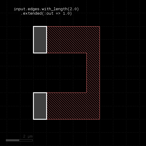
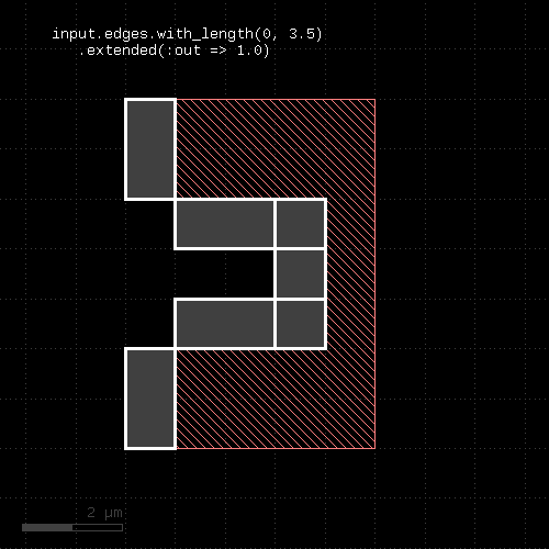
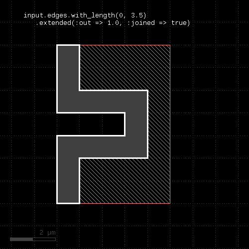
"extended" - Returns polygons describing an area along the edges of the input
Usage:
- layer.extended([:begin => b,] [:end => e,] [:out => o,] [:in => i], [:joined => true])
- layer.extended(b, e, o, i)
- layer.extended(b, e, o, i, joined)
This method is available for edge layers only. It will create a polygon for each edge tracing the edge with certain offsets to the edge. "o" is the offset applied to the outer side of the edge, "i" is the offset applied to the inner side of the edge. "b" is the offset applied at the beginning and "e" is the offset applied at the end.
When looking from start to end point, the "inside" side is to the right, while the "outside" side is to the left.
"joined" is a flag, which, if present, will make connected edges behave as a continuous line. Start and end offsets are applied to the first and last unconnected point respectively. Please note that in order to specify joined mode, you'll need to specify "joined" as a keyword in the third form of the method.
The following images show the effects of some parameters:
 |  |
 | 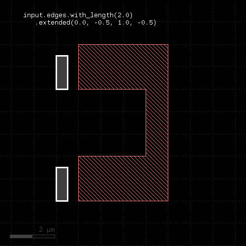 |
"extended_in" - Returns polygons describing an area along the edges of the input
Usage:
- layer.extended_in(d)
This method applies to edge layers only. Polygons are generated for each edge describing the edge drawn with a certain width extending into the "inside" (the right side when looking from start to end). This method is basically equivalent to the extended method: "extended(0, 0, 0, dist)". A version extending to the outside is extended_out.
"extended_out" - Returns polygons describing an area along the edges of the input
Usage:
- layer.extended_out(d)
This method applies to edge layers only. Polygons are generated for each edge describing the edge drawn with a certain width extending into the "outside" (the left side when looking from start to end). This method is basically equivalent to the extended method: "extended(0, 0, dist, 0)". A version extending to the inside is extended_in.
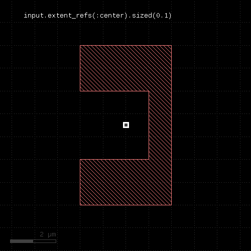
"extent_refs" - Returns partial references to the boundings boxes of the polygons
Usage:
- layer.extent_refs(fx, fy [, options ])
- layer.extent_refs(fx1, fy1, fx2, fx2 [, options ])
- layer.extent_refs(ref_spec [, options ])
This method produces parts of the bounding box of the polygons. It can select either edges, certain points or partial boxes. It can be used the following ways:
- With a formal specification : This is an identifier like ":center" or ":left" to indicate which part will be produced.
- With two floating-point arguments : These arguments specify a point relative to the bounding box. The first argument is a relative x coordinate where 0.0 means "left side of the bounding box" and 1.0 is the right side. The second argument is a relative y coordinate where 0.0 means "bottom" and 1.0 means "top". The results will be small (2x2 DBU) boxes or point-like edges for edge output
- With four floating-point arguments : These arguments specify a box in relative coordinates: a pair of x/y relative coordinate for the first point and another pair for the second point. The results will be boxes or a tilted edge in case of edge output. If the range specifies a finite-area box (height and width are not zero), no adjustment of the boxes will happen for polygon output - i.e. the additional enlargement by 1 DBU which is applied for zero-area boxes does not happen.
The formal specifiers are for points:
- :center or :c : the center point
- :bottom_center or :bc : the bottom center point
- :bottom_left or :bl : the bottom left point
- :bottom_right or :br : the bottom right point
- :left or :l : the left point
- :right or :r : the right point
- :top_center or :tc : the top center point
- :top_left or :tl : the top left point
- :top_right or :tr : the top right point
The formal specifiers for lines are:
- :bottom or :b : the bottom line
- :top or :t : the top line
- :left or :l : the left line
- :right or :r : the right line
The following additional option controls the output format:
- as_boxes : with this option, boxes (rectangular polygons) will be produced on output
- as_dots or as_edges : with this option, edges will be produced on output
Dots on are represented by small (2x2 DBU) boxes or point-like edges with edge output. Lines are represented by narrow or flat (2 DBU) boxes or edges for edge output. Edges will follow the orientation convention for the corresponding edges - i.e. "inside" of the bounding box is on the right side of the edge.
The following table shows a few applications:
 | |||||||
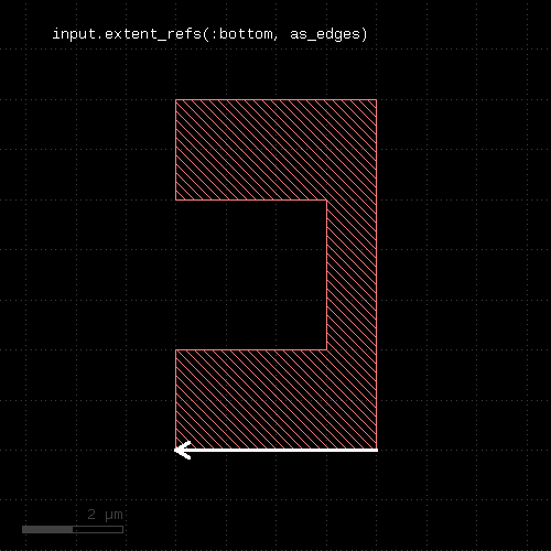 | 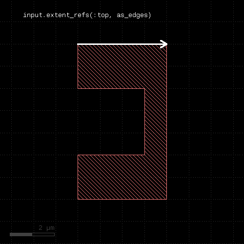 | 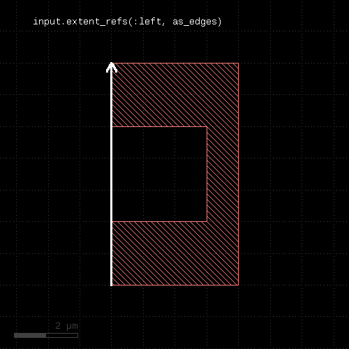 | 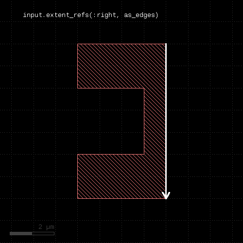 | ||||
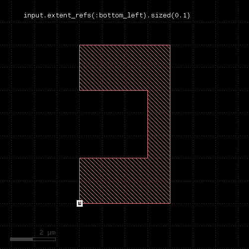 | 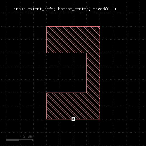 | 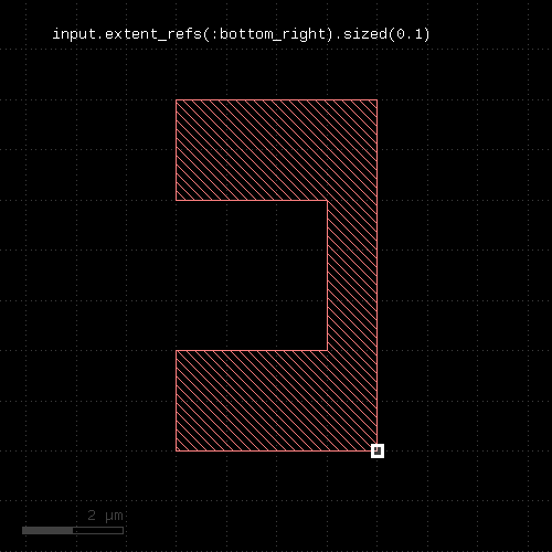 | 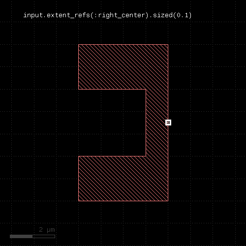 | 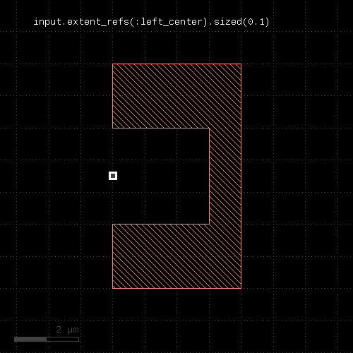 | 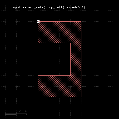 | 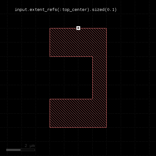 | 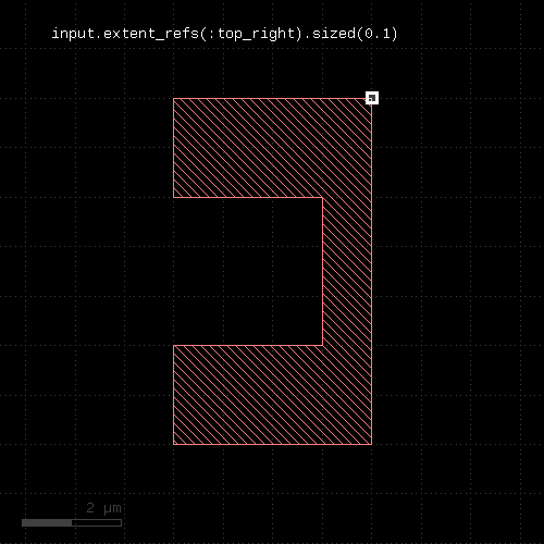 |
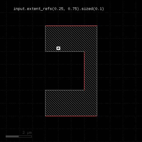 | 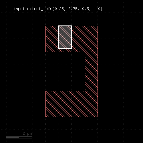 |
"extents" - Returns the bounding box of each input object
Usage:
- layer.extents([ enlargement ])
Applies to edge layers, polygon layers on edge pair collections. Returns a polygon layer consisting of boxes for each input object. The boxes enclose the original object.
Merged semantics applies, so the box encloses the merged polygons or edges unless raw mode is chosen (see raw).
The enlargement parameter specifies an optional enlargement which will make zero width/zero height object render valid polygons (i.e. horizontal/vertical edges).
The following images show the effect of the extents method:
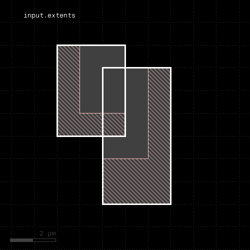 | 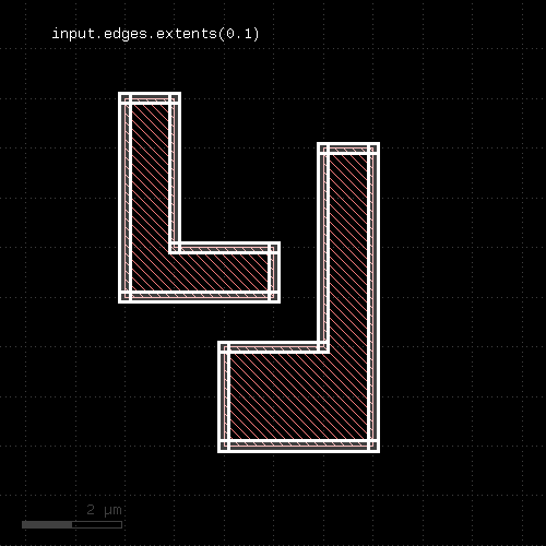 |
"fill" - Fills the region with regular pattern of shapes
Usage:
- layer.fill([ options ])
This method will attempt to fill the polygons of the layer with a regular pattern of shapes.
The fill function currently is not available in deep mode.
Options are:
- hstep(x) or hstep(x, y) : specifies the horizontal step pitch of the pattern. x must be a positive value. A vertical displacement component can be specified too, which results in a skewed pattern.
- vstep(y) or vstep(x, y) : specifies the vertical step pitch of the pattern. y must be a positive value. A horizontal displacement component can be specified too, which results in a skewed pattern.
- origin(x, y) : specifies a fixed point to align the pattern with. This point specifies the location of the reference point for one pattern cell.
- auto_origin : lets the algorithm choose the origin. This may result is a slightly better fill coverage as the algorithm is able to determine a pattern origin per island to fill.
- multi_origin : lets the algorithm choose the origin and repeats the fill with different origins until no further fill cell can be fitted.
- fill_pattern(..) : specifies the fill pattern.
- fill_exclude(excl) : specifies a fill exclude region ('excl' is a polygon layer). This is conceptually equivalent to subtracting that layer from the fill region, but usually more efficient.
"fill_pattern" generates a fill pattern object. This object is used for configuring the fill pattern content. Fill pattern need to be named. The name will be used for generating the fill cell.
To provide a fill pattern, create a fill pattern object and add shapes to it. The following example creates a fill pattern named "FILL_CELL" and adds a 1x1 micron box on layer 1/0:
p = fill_pattern("FILL_CELL")
p.shape(1, 0, box(0.0, 0.0, 1.0, 1.0))
See box for details about the box specification. You can also add paths or polygons with path or polygon.
A more compact way of writing this is:
p = fill_pattern("FILL_CELL").shape(1, 0, box(0.0, 0.0, 1.0, 1.0))
The "shape" method takes several forms:
- shape(layer, object, object ...) (1)
- shape(layer, datatype, object, object ...) (2)
- shape(name, object, object ...) (3)
- shape(layer_info, object, object ...) (4)
The first form takes a GDS2 layer number. The datatype is assumed to be 0. The second form takes a GDS layer and datatype number. The third form takes a layer name for layout systems with named layers (like Magic, CIF or DXF). The forth form takes a LayerInfo object to specify the layer. All forms take one to many geometry objects which are written to the respective layer. Geometry objects can either be created using the generator functions (box, polygon, path). The core classes DBox, DPolygon, DPath or DText are also accepted as geometry objects.
The fill pattern can be given a reference point which is used for placing the pattern. The reference point is the one which is aligned with the pattern origin. The following code will assign (-0.5, -0.5) as the reference point for the 1x1 micron rectangle. Hence the reference point is a little below and left of the rectangle which in turn shifts the rectangle fill pattern to the right and up:
p = fill_pattern("FILL_CELL")
p.shape(1, 0, box(0.0, 0.0, 1.0, 1.0))
p.origin(-0.5, -0.5)
Without a reference point given, the lower left corner of the fill pattern's bounding box will be used as the reference point. The reference point will also defined the footprint of the fill cell - more precisely the lower left corner. When step vectors are given, the fill cell's footprint is taken to be a rectangle having the horizontal and vertical step pitch for width and height respectively. This way the fill cells will be arrange seamlessly.
However, the cell's dimensions can be changed, so that the fill cells can overlap or there is a space between the cells. To change the dimensions use the "dim" method. This example will use a fill cell footprint of 1x1 micrometers, regardless of the step pitch:
p = fill_pattern("FILL_CELL")
p.shape(1, 0, box(0.0, 0.0, 1.0, 1.0))
p.dim(1.0, 1.0)
The following example specifies a fill cell with an active area of -0.5 .. 1.5 in both directions (2 micron width and height). With these dimensions the fill cell's footprint is independent of the step pitch:
p = fill_pattern("FILL_CELL")
p.shape(1, 0, box(0.0, 0.0, 1.0, 1.0))
p.origin(-0.5, -0.5)
p.dim(2.0, 2.0)
Finally, the fill cell can be given a margin: this is a space around the fill cell which needs to be inside the fill region. Hence, the margin can be used to implement a distance, the fill cells (more precisely: their footprints) will maintain to the outside border of the fill region. The following example implements a margin of 200 nm in horizontal and 250 nm in vertical direction:
p = fill_pattern("FILL_CELL")
p.shape(1, 0, box(0.0, 0.0, 1.0, 1.0))
p.dim(1.0, 1.0)
p.margin(0.2, 0.25)
With these ingredients will can use the fill function. The first example fills the polygons of "to_fill" with an orthogonal pattern of 1x1 micron rectangles with a pitch of 2 microns:
pattern = fill_pattern("FILL_CELL").shape(1, 0, box(0.0, 0.0, 1.0, 1.0)).origin(-0.5, -0.5)
to_fill.fill(pattern, hstep(2.0), vstep(2.0))
This second example will create a skewed fill pattern in auto-origin mode:
pattern = fill_pattern("FILL_CELL").shape(1, 0, box(0.0, 0.0, 1.0, 1.0)).origin(-0.5, -0.5)
to_fill.fill(pattern, hstep(2.0, 1.0), vstep(-1.0, 2.0), auto_origin)
The fill function can only work with a target layout for output. It will not work for report output.
The layers generated by the fill cells is only available for input later in the script if the output layout is identical to the input layouts. If you need the area missed by the fill function, try fill_with_left.
"fill_with_left" - Fills the region with regular pattern of shapes
Usage:
- layer.fill_with_left([ options ])
This method has the same call syntax and functionality than fill. Other than this method it will return the area not covered by fill cells as a DRC layer.
"first_edges" - Returns the first edges of an edge pair collection
Usage:
- layer.first_edges
Applies to edge pair collections only. Returns the first edges of the edge pairs in the collection.
Some checks deliver symmetric edge pairs (e.g. space, width, etc.) for which the edges are commutable. "first_edges" will deliver both edges for such edge pairs.
"flatten" - Flattens the layer
Usage:
- layer.flatten
If the layer already is a flat one, this method does nothing. If the layer is a hierarchical layer (an original layer or a derived layer in deep mode), this method will convert it to a flat collection of texts, polygons, edges or edge pairs.
"forget" - Cleans up memory for this layer
Usage:
- forget
KLayout's DRC engine is imperative. This means, every command is executed immediately rather than being compiled and executed later. The advantage of this approach is that it allows decisions to be taken depending on the content of a layer and to code functions that operate directly on the layer's content.
However, one drawback is that the engine cannot decide when a layer is no longer required - it may still be used later in the script. So a layer's data is not cleaned up automatically.
In order to save memory for DRC scripts intended for bigger layouts, the DRC script should clean up layers as soon as they are no longer required. The "forget" method will free the memory used for the layer's information.
The recommended approach is:
l = ... # compute some layer
...
# once you're done with l:
l.forget
l = nil
By setting the layer to nil, it is ensured that it can no longer be accessed.
"hier_count" - Returns the hierarchical number of objects on the layer
Usage:
- layer.hier_count
The hier_count is the number of raw objects, not merged regions or edges, with each cell counting once. A high count to hier_count (flat to hierarchical) ratio is an indication of a good hierarchical compression. "hier_count" applies only to original layers without clip regions or cell filters and to layers in deep mode. Otherwise, hier_count gives the same value than count.
"holes" - Selects all polygon holes from the input
Usage:
- layer.holes
This method is available for polygon layers. It will create polygons from all holes inside polygons of the input. Although it is possible, running this method on raw polygon layers will usually not render the expected result, since raw layers do not contain polygons with holes in most cases.
The following image shows the effects of the holes method:
 |
"hulls" - Selects all polygon hulls from the input
Usage:
- layer.hulls
This method is available for polygon layers. It will remove all holes from the input and render the hull polygons only. Although it is possible, running this method on raw polygon layers will usually not render the expected result, since raw layers do not contain polygons with holes in most cases.
The following image shows the effects of the hulls method:
 |
"in" - Selects shapes or regions of self which are contained in the other layer
Usage:
- layer.in(other)
This method selects all shapes or regions from self which are contained the other region exactly. It will use individual shapes from self or other if the respective region is in raw mode. If not, it will use coherent regions or combined edges from self or other.
It will return a new layer containing the selected shapes. A method which selects all shapes not contained in the other layer is not_in.
This method is available for polygon and edge layers.
The following image shows the effect of the "in" method (input1: red, input2: blue):
 |
"in_and_out" - Selects shapes or regions of self which are and which are not contained in the other layer
Usage:
- (in, not_in) = layer.in_and_out(other)
This method is equivalent to calling in and not_in, but more efficient as it delivers both results in a single call.
"insert" - Inserts one or many objects into the layer
Usage:
- insert(object, object ...)
Objects that can be inserted are Edge objects (into edge layers) or DPolygon, DSimplePolygon, Path, DBox (into polygon layers). Convenience methods exist to create such objects (edge, polygon, box and path). However, RBA constructors can used as well.
The insert method is useful in combination with the polygon_layer or edge_layer functions:
el = edge_layer
el.insert(edge(0.0, 0.0, 100.0, 0.0)

pl = polygon_layer
pl.insert(box(0.0, 0.0, 100.0, 200.0)
"inside" - Selects edges, edge pairs or polygons of self which are inside edges or polygons from the other layer
Usage:
- layer.inside(other)
If layer is a polygon layer, the other layer needs to be a polygon layer too. In this case, this method selects all polygons which are completely inside polygons from the other layer.
If layer is an edge pair layer, the other layer needs to be a polygon layer. In this case, this method selects all edge pairs which are completely inside polygons from the other layer.
If layer is an edge layer, the other layer can be polygon or edge layer. In the first case, all edges completely inside the polygons from the other layer are selected. If the other layer is an edge layer, all edges completely contained in edges from the other layer are selected.
Merged semantics applies - i.e. edges or polygons are joined before the result is computed, unless the layers are in raw mode.
This method returns a new layer containing the selected shapes. A version which modifies self is select_inside. not_inside is a function computing the inverse of inside. split_inside is a function computing both results in a single call. outside is a similar function selecting edges or polygons outside other edges or polygons.
The following image shows the effect of the "inside" method for polygons (input1: red, input2: blue):
 |
The following images show the effect of the "inside" method for edge layers and edge or polygon layers the second input. Note that the edges are computed from the polygons in this example (input1: red, input2: blue):
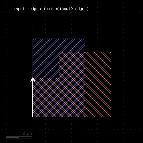 |
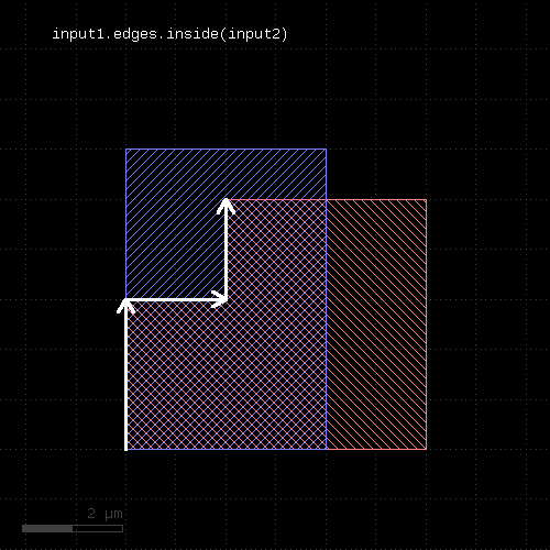 |
"inside_outside_part" - Returns the parts of the edges inside and outside the given region
Usage:
- (inside_part, outside_part) = layer.inside_outside_part(region)
The method is available for edge layers. The argument must be a polygon layer.
This method returns two layers: the first with the edge parts inside the given region and the second with the parts outside the given region. It is equivalent to calling inside_part and outside_part, but more efficient if both parts need to be computed.
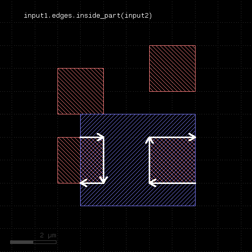
"inside_part" - Returns the parts of the edges inside the given region
Usage:
- layer.inside_part(region)
This method returns the parts of the edges which are inside the given region. This is similar to the "&" operator, but this method does not return edges that are exactly on the boundaries of the polygons of the region.
This method is available for edge layers. The argument must be a polygon layer.
outside_part is a method computing the opposite part. inside_outside_part is a method computing both inside and outside part in a single call.
 |
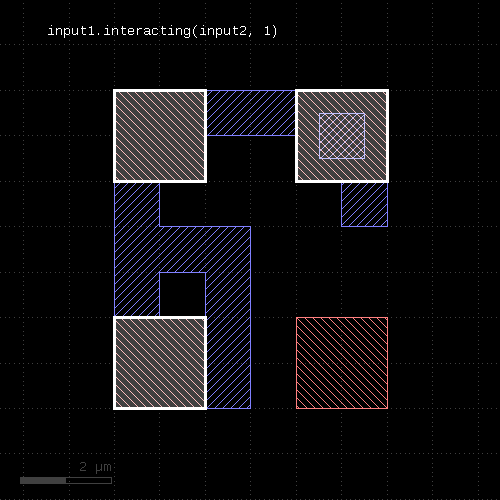
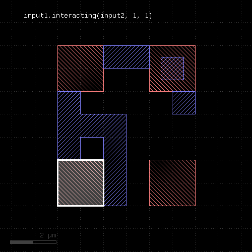
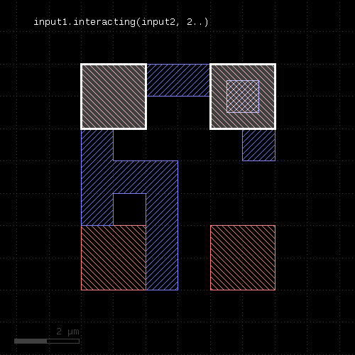
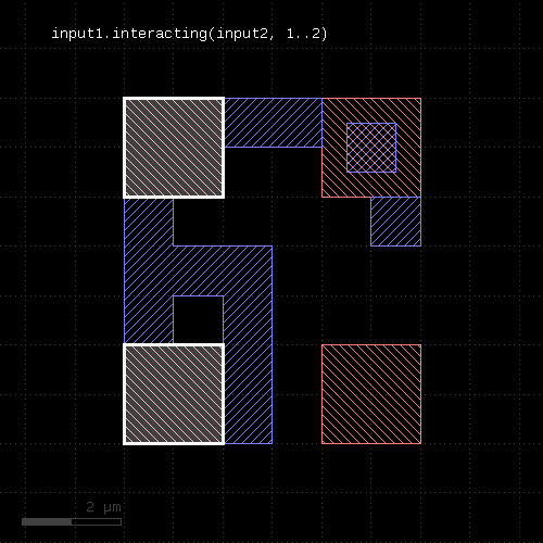
"interacting" - Selects shapes or regions of self which touch or overlap shapes from the other region
Usage:
- layer.interacting(other)
- layer.interacting(other, min_count)
- layer.interacting(other, min_count, max_count)
- layer.interacting(other, min_count .. max_count)
This method selects all shapes or regions from self which touch or overlap shapes from the other region. Unless self is in raw mode (see raw), coherent regions are selected from self, otherwise individual shapes are selected. It returns a new layer containing the selected shapes. A version which modifies self is select_interacting.
This method is available for polygon, text, edge and edge pair layers. Edges and edge pairs can be selected with respect to other edges or polygons. Texts can be selected with respect to polygons. Polygons can be selected with respect to edges, texts and other polygons.
The following image shows the effect of the "interacting" method (input1: red, input2: blue):
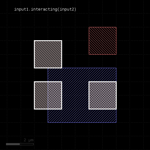 |
If a single count is given, shapes from self are selected only if they do interact at least with the given number of (different) shapes from the other layer. If a min and max count is given, shapes from self are selected only if they interact with min_count or more, but a maximum of max_count different shapes from the other layer. Two polygons overlapping or touching at two locations are counted as single interactions.
 |  |
 |  |
"intersections" - Returns the intersection points of intersecting edge segments for two edge collections
Usage:
- layer.intersections(edges)
This operation is similar to the "&" operator, but it does also report intersection points between non-colinear, but intersecting edges. Such points are reported as point-like, degenerated edge objects.
This method is available for edge layers. The argument must be an edge layer.
"is_box?" - Returns true, if the region contains a single box
Usage:
- layer.is_box?
The method returns true, if the region consists of a single box only. Merged semantics does not apply - if the region forms a box which is composed of multiple pieces, this method will not return true.
"is_clean?" - Returns true, if the layer is clean state
Usage:
- layer.is_clean?
See clean for a discussion of the clean state.
"is_deep?" - Returns true, if the layer is a deep (hierarchical) layer
Usage:
- layer.is_deep?
"is_empty?" - Returns true, if the layer is empty
Usage:
- layer.is_empty?
"is_merged?" - Returns true, if the polygons of the layer are merged
Usage:
- layer.is_merged?
This method will return true, if the polygons of this layer are merged, i.e. they don't overlap and form single continuous polygons. In clean mode, this is ensured implicitly. In raw mode (see raw), merging can be achieved by using the merge method. is_merged? tells, whether calling merge is necessary.
"is_raw?" - Returns true, if the layer is raw state
Usage:
- layer.is_raw?
See clean for a discussion of the raw state.
"iso" - An alias for "isolated"
Usage:
- layer.iso(value [, options])
See isolated for a description of that method
"isolated" - An inter-polygon isolation check
Usage:
- layer.isolated(value [, options])
- layer.iso(value [, options])
Note: "isolated" and "iso" are available as operators for the "universal DRC" function Layer#drc within the DRC framework. These variants have more options and are more intuitive to use. See isolated for more details.
See space for a description of this method. "isolated" is the space check variant which checks different polygons only. In contrast to space, the "isolated" method is available for polygon layers only, since only on such layers different polygons can be identified.
"iso" is the short form of this method.
The following image shows the effect of the isolated check:
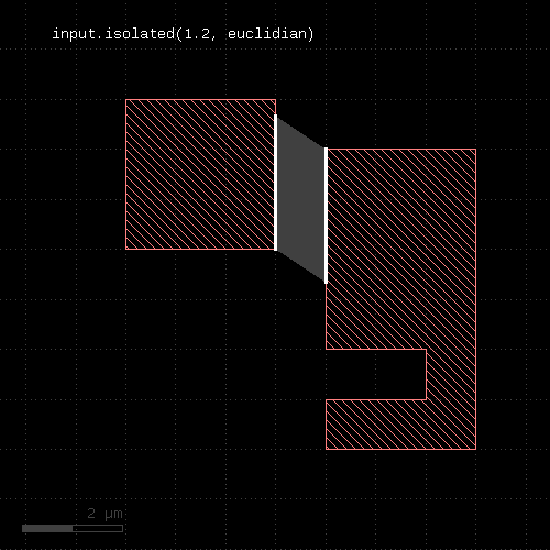 |
"join" - Joins the layer with another layer
Usage:
- layer.join(other)
The method includes the edges or polygons from the other layer into this layer. It is an alias for the "+" operator.
This method is available for polygon, edge and edge pair layers.
The following images show the effect of the "join" method on polygons and edges (input1: red, input2: blue):
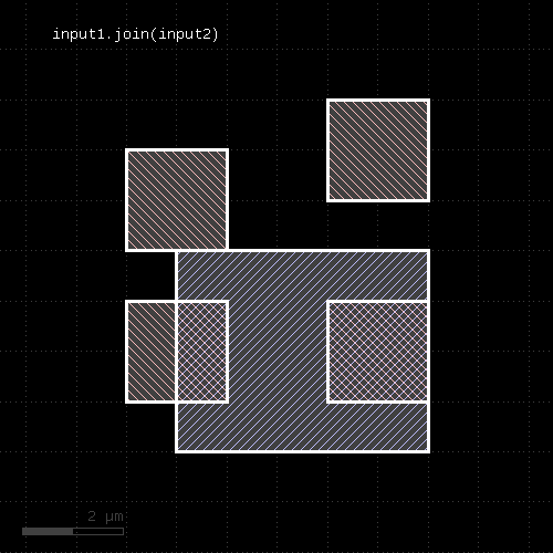 | 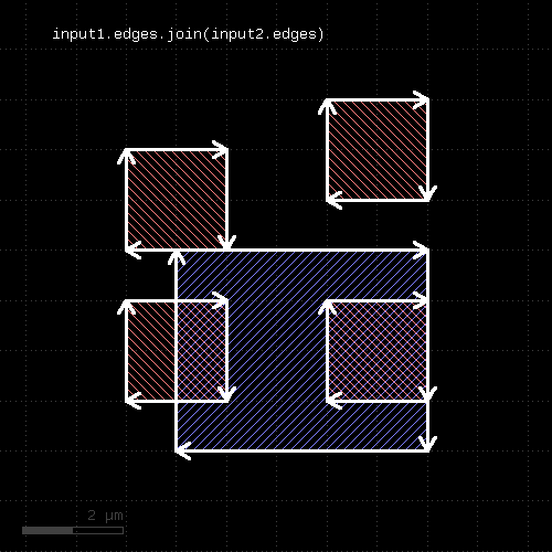 |
"length" - Returns the total length of the edges in the edge layer
Usage:
- layer.length
This method requires an edge layer. It returns the total length of all edges in micron. Merged semantics applies, i.e. before computing the length, the edges are merged unless raw mode is chosen (see raw). Hence in clean mode (see clean), overlapping edges are not counted twice.
"map_props" - Selects properties with certain keys and allows key mapping
Usage:
- layer.map_props({ key => key_new, .. })
Similar to select_props, this method will map or filter properties and and take the values from certain keys. In addition, this method allows mapping keys to new keys. Specify a hash argument with old to new keys.
Property values with keys not listed in the hash are removed.
Note that this method returns a new layer with the new properties. The original layer will not be touched.
For example to map key 2 to 1 (integer name keys) and ignore other keys, use:
layer1 = input(1, 0, enable_properties)
layer1_mapped = layer1.map_props({ 2 => 1 })
See also select_props and remove_props.
"merge" - Merges the layer (modifies the layer)
Usage:
- layer.merge([overlap_count])
Like merged, but modifies the input and returns a reference to the new layer.
"merge_props" - Merges the layer and joins the properties (modifies the layer)
Usage:
- layer.merge_props([overlap_count])
Like merged_props, but modifies the input and returns a reference to the new layer.
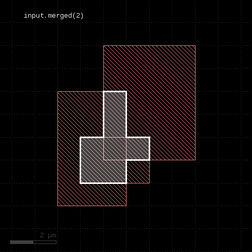
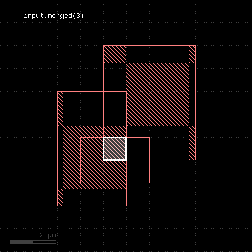
"merged" - Returns the merged layer
Usage:
- layer.merged([overlap_count])
Returns the merged input. Usually, merging is done implicitly using the clean state (which is default). However, in raw state, merging can be enforced by using this method. In addition, this method allows specification of a minimum overlap count, i.e. only where at least the given number of polygons overlap, output is produced. See sized for an application of that.
This method works both on edge or polygon layers. Edge merging forms single, continuous edges from coincident and connected individual edges. The overlap count is only available on polygon layers.
A version that modifies the input layer is merge.
The following images show the effect of various forms of the "merged" method:
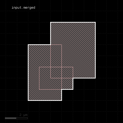 |  |
 |  |
"merged_props" - Merges and joins properties of the shapes
Usage:
- layer.merged_props([overlap_count])
Returns the merged input. Unlike the plain merged method, this version will join properties on merged shapes. Properties with the same name will be merged by computing the maximum value of the parts.
For example: Properties { "A" => 17, "C" => 2.5 } merged with { "A" => 1, "B" => "a text" } will give { "A" => 17, "B" => "a text", "C" => 2.5 } .
The plain merged method will treat shapes with different properties as separate entities and will not merge them.
Currently, this method is available for polygon layers only.
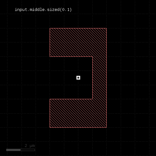
"middle" - Returns the center points of the bounding boxes of the polygons
Usage:
- layer.middle([ options ])
This method produces markers on the centers of the polygon's bounding box centers. These markers can be point-like edges or small 2x2 DBU boxes. The latter is the default. A more generic function is extent_refs. "middle" is basically a synonym for "extent_refs(:center)".
The options available are:
- as_boxes : with this option, small boxes will be produced as markers
- as_dots : with this option, point-like edges will be produced instead of small boxes
The following image shows the effect of this method
 |
"move" - Moves (shifts, translates) a layer (modifies the layer)
Usage:
- layer.move(dx, dy)
Moved the input by the given distance. The layer that this method is called upon is modified and the modified version is returned for further processing.
Shift distances can be given as floating-point values (in micron) or integer values (in database units). To explicitly specify the unit, use the unit denominators.
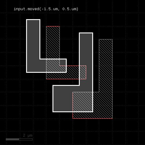
"moved" - Moves (shifts, translates) a layer
Usage:
- layer.moved(dx, dy)
Moves the input layer by the given distance (x, y) and returns the moved layer. The layer that this method is called upon is not modified.
Shift distances can be given as floating-point values (in micron) or integer values (in database units). To explicitly specify the unit, use the unit denominators.
The following images shows the effect of the "moved" method:
 |
"nets" - Pulls net shapes from selected or all nets, optionally annotating nets with properties
Usage:
- layer.nets
- layer.nets(net_filter)
- layer.nets(net_object)
- layer.nets(circuit_filter, net_filter)
- layer.nets(netter, ...)
- layer.nets(prop(key), ...)
- layer.nets(prop(key), ...)
This method needs a layer that has been used in a connect statement. It will take the shapes corresponding to this layer for all or selected nets and attach the net identity in form of a user property.
This way, the resulting shapes can be used in property-constrained boolean operations or DRC checks to implement operations in connected or non-connected mode.
A glob-style name pattern can be supplied to filter nets. Nets are always complete - subnets from subcircuits are not selected. The net name is taken from the net's home circuit (to topmost location where all net connections are formed). You can specify a circuit filter to select nets from certain circuits only or give a Circuit object explicitly. You can also specify Net objects directly.
connect(metal1, via1)
connect(via1, metal2)

metal1_all_nets = metal1.nets
metal1_vdd      = metal1.nets("VDD")
metal1_vdd      = metal1.nets("TOPLEVEL", "VDD")
By default, the property key used for the net identity is numerical 0 (integer). You can change the key by giving a property key with the "prop" qualifier. Using "nil" for the key will disable properties:
metal1_vdd = metal1.nets("VDD", prop(1))
# disables properties:
metal1_vdd = metal1.nets("VDD", prop(nil))
If a custom netter object has been used for the construction of the connectivity, pass it to the "nets" method among the other arguments.
"non_rectangles" - Selects all polygons from the input which are not rectangles
Usage:
- layer.non_rectangles
This method is available for polygon layers. By default "merged" semantics applies, i.e. all polygons are merged before non-rectangles are selected (see clean and raw).
"non_rectilinear" - Selects all non-rectilinear polygons from the input
Usage:
- layer.non_rectilinear
This method is available for polygon layers. By default "merged" semantics applies, i.e. all polygons are merged before non-rectilinear polygons are selected (see clean and raw).
"non_squares" - Selects all polygons from the input which are not squares
Usage:
- layer.non_rectangles
This method is available for polygon layers. By default "merged" semantics applies, i.e. all polygons are merged before non-squares are selected (see clean and raw).
"non_strict" - Marks a layer for non-strict handling
Usage:
- layer.non_strict
See strict for details about this option.
This feature has been introduced in version 0.23.2.
"not" - Boolean NOT operation
Usage:
- layer.not(other [, prop_constraint ])
The method computes a boolean NOT between self and other. It is an alias for the "-" operator.
This method is available for polygon and edge layers. If the first operand is an edge layer and the second is an edge layer, the result will be the edges of the first operand which are outside the polygons of the second operand.
The following images show the effect of the "not" method on polygons and edges (input1: red, input2: blue):
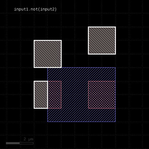 | 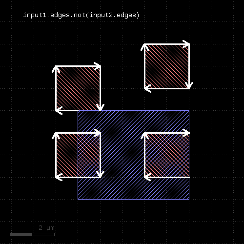 | 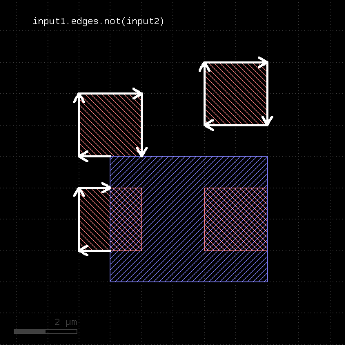 |
The NOT operation can be applied between a text and a polygon layer. In this case, the texts outside the polygons will be written to the output (labels: red, input2: blue):
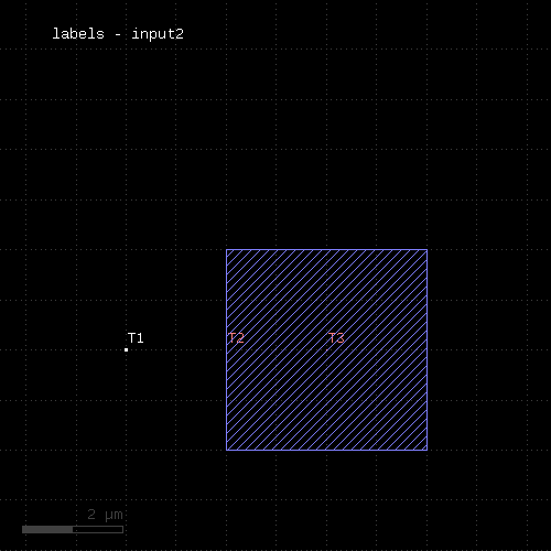 |
When a properties constraint is given, the operation is performed only between shapes with the given relation. Together with the ability to provide net-annotated shapes through the nets method, this allows constraining the boolean operation to shapes from the same or from different nets.
See prop_eq, prop_ne and prop_copy for details.
"not_covering" - Selects shapes or regions of self which do not cover (enclose) one or more shapes from the other region
Usage:
- layer.not_covering(other)
- layer.not_covering(other, min_count)
- layer.not_covering(other, min_count, max_count)
- layer.not_covering(other, min_count .. max_count)
This method selects all shapes or regions from self which do not cover shapes from the other region. Unless self is in raw mode (see raw), coherent regions are selected from self, otherwise individual shapes are selected. This method returns the inverse of covering and provides the same options.
The following image shows the effect of the "not_covering" method:
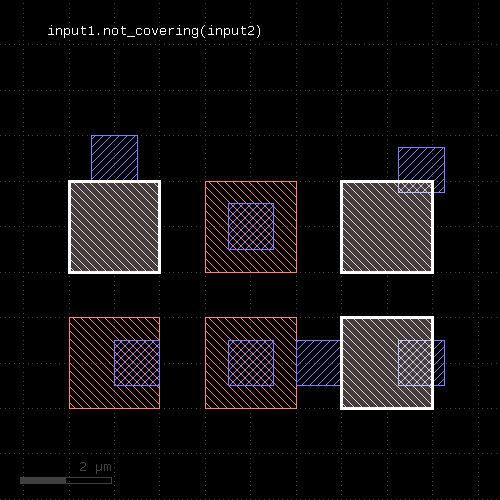 |
This method is available for polygons only. It returns a new layer containing the selected shapes. A version which modifies self is select_not_covering.
"not_in" - Selects shapes or regions of self which are not contained in the other layer
Usage:
- layer.not_in(other)
This method selects all shapes or regions from self which are not contained the other region exactly. It will use individual shapes from self or other if the respective region is in raw mode. If not, it will use coherent regions or combined edges from self or other.
It will return a new layer containing the selected shapes. A method which selects all shapes contained in the other layer is in.
This method is available for polygon and edge layers.
The following image shows the effect of the "not_in" method (input1: red, input2: blue):
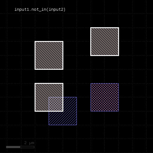 |
"not_inside" - Selects edges, edge pairs or polygons of self which are not inside edges or polygons from the other layer
Usage:
- layer.not_inside(other)
This method computes the inverse of inside - i.e. edge, edge pairs or polygons from the layer not being inside polygons or edges from the other layer.
This method returns a new layer containing the selected shapes. A version which modifies self is select_not_inside. split_inside is a function computing both results of inside and not_inside in a single call. outside is a similar function selecting edges or polygons outside other edges or polygons. Note that "outside" is not the same than "not inside".
The following image shows the effect of the "not_inside" method for polygon layers (input1: red, input2: blue):
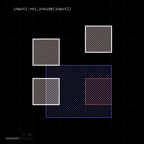 |
The following images show the effect of the "not_inside" method for edge layers and edge or polygon layers the second input. Note that the edges are computed from the polygons in this example (input1: red, input2: blue):
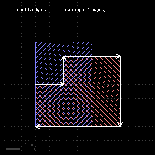 |
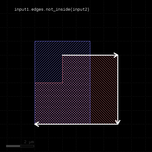 |
"not_interacting" - Selects shapes or regions of self which do not touch or overlap shapes from the other region
Usage:
- layer.not_interacting(other)
- layer.not_interacting(other, min_count)
- layer.not_interacting(other, min_count, max_count)
- layer.not_interacting(other, min_count .. max_count)
This method selects all shapes or regions from self which do not touch or overlap shapes from the other region. Unless self is in raw mode (see raw), coherent regions are selected from self, otherwise individual shapes are selected. It returns a new layer containing the selected shapes. A version which modifies self is select_not_interacting.
This method is available for polygon, text, edge and edge pair layers. Edges and edge pairs can be selected with respect to other edges or polygons. Texts can be selected with respect to polygons. Polygons can be selected with respect to edges, texts and other polygons.
The following image shows the effect of the "not_interacting" method (input1: red, input2: blue):
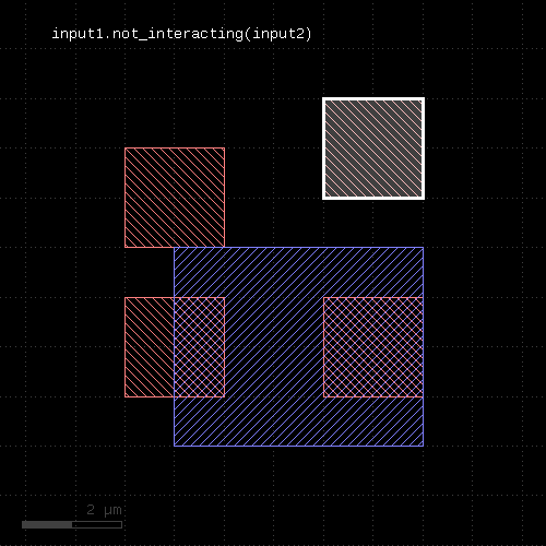 |
If a single count is given, shapes from self are selected only if they interact with less than the given number of (different) shapes from the other layer. If a min and max count is given, shapes from self are selected only if they interact with less than min_count or more than max_count different shapes from the other layer. Two polygons overlapping or touching at two locations are counted as single interactions.
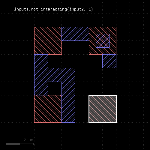 | 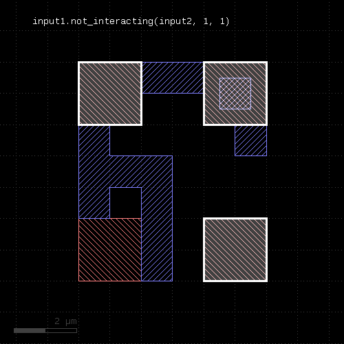 |
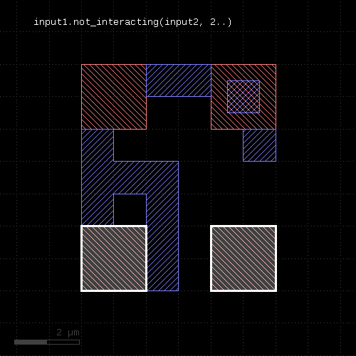 | 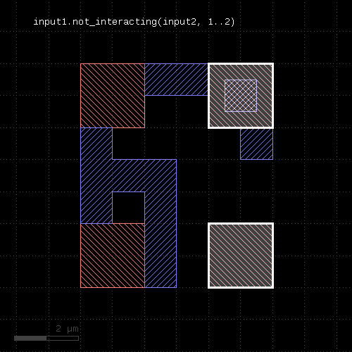 |
"not_outside" - Selects edges, edge pairs or polygons of self which are not outside edges or polygons from the other layer
Usage:
- layer.not_outside(other)
This method computes the inverse of outside - i.e. edges, edge pairs or polygons from the layer not being outside polygons or edges from the other layer.
This method returns a new layer containing the selected shapes. A version which modifies self is select_not_outside. split_outside is a function computing both results of outside and not_outside in a single call. outside is a similar function selecting edges or polygons outside other edges or polygons. Note that "outside" is not the same than "not outside".
The following image shows the effect of the "not_outside" method for polygon layers (input1: red, input2: blue):
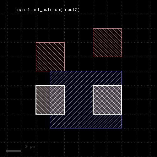 |
The following images show the effect of the "not_outside" method for edge layers and edge or polygon layers the second input. Note that the edges are computed from the polygons in this example (input1: red, input2: blue):
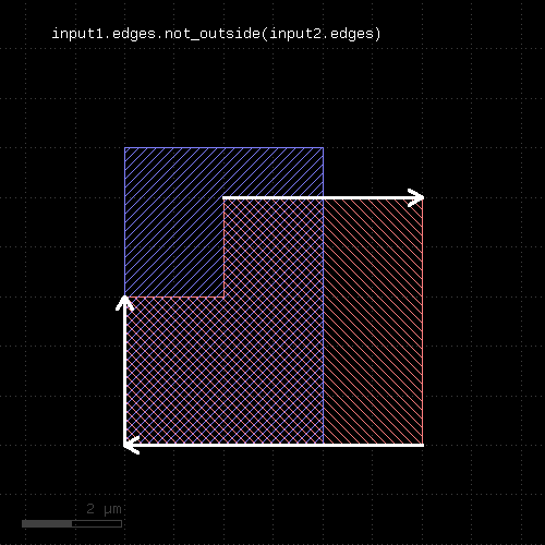 |
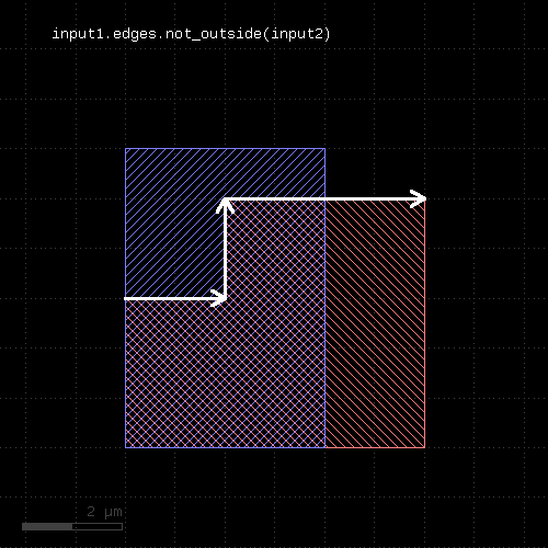 |
"not_overlapping" - Selects shapes or regions of self which do not overlap shapes from the other region
Usage:
- layer.not_overlapping(other)
- layer.not_overlapping(other, min_count)
- layer.not_overlapping(other, min_count, max_count)
- layer.not_overlapping(other, min_count .. max_count)
This method selects all shapes or regions from self which do not overlap shapes from the other region. Unless self is in raw mode (see raw), coherent regions are selected from self, otherwise individual shapes are selected. This method will return the inverse of overlapping and provides the same options.
The "not_overlapping" method is similar to the outside method. However, "outside" does not provide the option to specify counts.
This method is available for polygons only. It returns a new layer containing the selected shapes. A version which modifies self is select_not_overlapping.
"notch" - An intra-polygon spacing check
Usage:
- layer.notch(value [, options])
Note: "notch" is available as an operator for the "universal DRC" function Layer#drc within the DRC framework. This variant has more options and is more intuitive to use. See notch for more details.
See space for a description of this method. "notch" is the space check variant which finds space violations within a single polygon, but not against other polygons. In contrast to space, the "notch" method is available for polygon layers only, since only on such layers different polygons can be identified. Also, opposite and rectangle error filtering is not available for this method.
The following image shows the effect of the notch check:
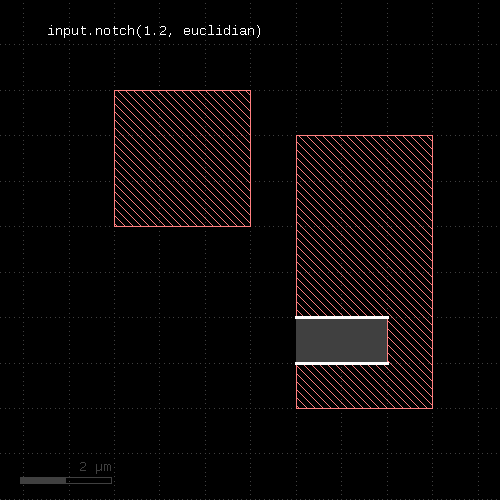 |
"odd_polygons" - Checks for odd polygons (self-overlapping, non-orientable)
Usage:
- layer.odd_polygons
Returns the parts of the polygons which are not orientable (i.e. "8" configuration) or self-overlapping. Merged semantics does not apply for this method. Always the raw polygons are taken (see raw).
The odd_polygons check is not available in deep mode currently. See deep_reject_odd_polygons for an alternative.
"ongrid" - Checks for on-grid vertices
Usage:
- layer.ongrid(g)
- layer.ongrid(gx, gy)
Returns a single-vertex marker for each vertex whose x coordinate is not a multiple of g or gx or whose y coordinate is not a multiple of g or gy. The single-vertex markers are edge pair objects which describe a single point. When setting the grid to 0, no grid check is performed in that specific direction.
This method requires a polygon layer. Merged semantics applies (see raw and clean).
"or" - Boolean OR operation
Usage:
- layer.or(other)
The method computes a boolean OR between self and other. It is an alias for the "|" operator.
This method is available for polygon and edge layers.
The following images show the effect of the "or" method on polygons and edges (input1: red, input2: blue):
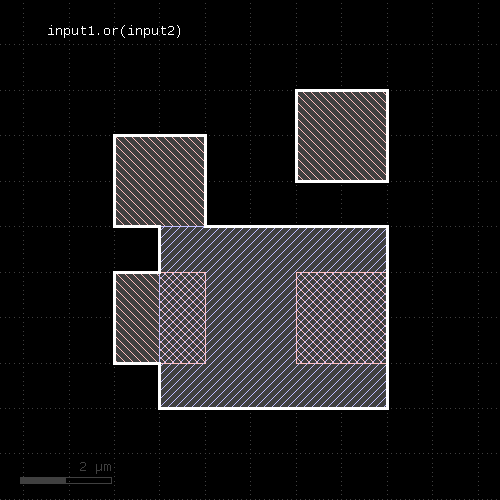 | 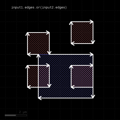 |
"output" - Outputs the content of the layer
Usage:
- layer.output(specs)
This method will copy the content of the layer to the specified output.
If a report database is selected for the output, the specification has to include a category name and optionally a category description. The category name can be an array of strings - in that case, a hierarchy of categories is created with the first array item being the top level category name. Shapes are added to an existing category, if a category with the given name already exists.
If the layout is selected for the output, the specification can consist of one to three parameters: a layer number, a data type (optional, default is 0) and a layer name (optional). Alternatively, the output can be specified by a single LayerInfo object.
See report and target on how to configure output to a target layout or report database.
See also new_target and new_report on how to create additional targets for output. This allows saving certain layers to different files than the standard target or report. To do so, create a new target or report using one of these functions and pass that object to the corresponding "output" call as an additional argument.
Example:
check1 = ...
check2 = ...
check3 = ...

second_report = new_report("Only for check2", "check2.lyrdb")

check1.output("Check 1")
check2.output("Check 2", second_report)
check3.output("Check 3")
"outside" - Selects edges, edge pairs or polygons of self which are outside edges or polygons from the other layer
Usage:
- layer.outside(other)
If layer is a polygon layer, the other layer needs to be a polygon layer too. In this case, this method selects all polygons which are entirely outside polygons from the other layer.
If layer is an edge pair layer, the other layer needs to be a polygon layer. In this case, this method selects all edge pairs which are entirely outside polygons from the other layer.
If layer is an edge layer, the other layer can be polygon or edge layer. In the first case, all edges entirely outside the polygons from the other layer are selected. If the other layer is an edge layer, all edges entirely outside of edges from the other layer are selected.
Merged semantics applies - i.e. edges or polygons are joined before the result is computed, unless the layers are in raw mode.
This method returns a new layer containing the selected shapes. A version which modifies self is select_outside. not_outside is a function computing the inverse of outside. split_outside is a function computing both results in a single call. outside is a similar function selecting edges or polygons outside other edges or polygons.
The following image shows the effect of the "outside" method for polygons (input1: red, input2: blue):
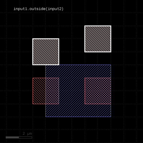 |
The following images show the effect of the "outside" method for edge layers and edge or polygon layers the second input. Note that the edges are computed from the polygons in this example (input1: red, input2: blue):
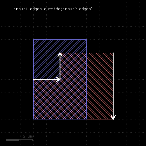 |
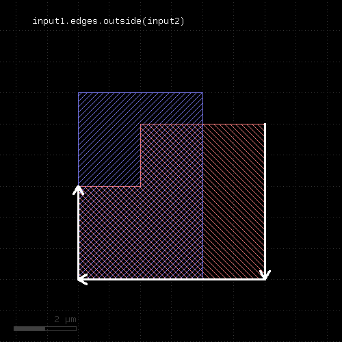 |
"outside_part" - Returns the parts of the edges outside the given region
Usage:
- layer.outside_part(region)
This method returns the parts of the edges which are outside the given region. This is similar to the "&" operator, but this method does not remove edges that are exactly on the boundaries of the polygons of the region.
This method is available for edge layers. The argument must be a polygon layer.
inside_part is a method computing the opposite part. inside_outside_part is a method computing both inside and outside part in a single call.
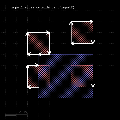 |
"overlap" - An overlap check
Usage:
- layer.overlap(other_layer, value [, options])
Note: "overlap" is available as an operator for the "universal DRC" function drc within the DRC framework. This variant has more options and is more intuitive to use. See overlap for more details.
This method checks whether layer and other_layer overlap by at least the given length. Locations, where this is not the case will be reported in form of edge pair error markers. Locations, where both layers touch will be reported as errors as well. Formally such locations form an overlap with a value of 0. Locations, where both regions do not overlap or touch will not be reported. Such regions can be detected with outside or by a boolean "not".
The options are the same as for separation.
Formally, the overlap method is a two-layer width check. In contrast to the single- layer width method (width), the zero value also triggers an error and separate polygons are checked against each other, while for the single-layer width, only single polygons are considered.
The overlap method can be applied to both edge or polygon layers. On edge layers the orientation of the edges matters: only edges which run back to back with their inside side pointing towards each other are checked for distance.
As for the other DRC methods, merged semantics applies.
Distance values can be given as floating-point values (in micron) or integer values (in database units). To explicitly specify the unit, use the unit denominators.
The following images show the effect of the overlap check (input1: red, input2: blue):
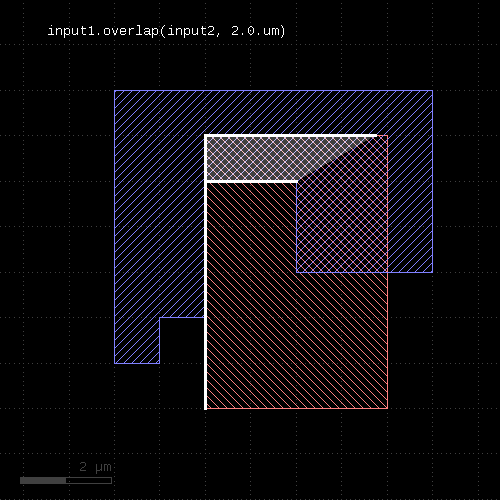 | 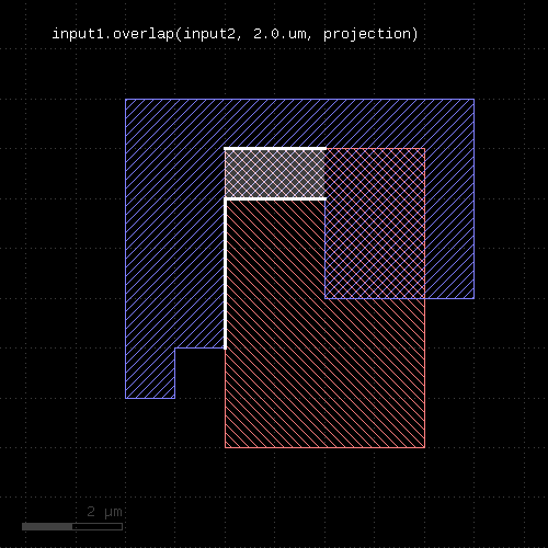 |
"overlapping" - Selects shapes or regions of self which overlap shapes from the other region
Usage:
- layer.overlapping(other)
- layer.overlapping(other, min_count)
- layer.overlapping(other, min_count, max_count)
- layer.overlapping(other, min_count .. max_count)
This method selects all shapes or regions from self which overlap shapes from the other region. Unless self is in raw mode (see raw), coherent regions are selected from self, otherwise individual shapes are selected. It returns a new layer containing the selected shapes. A version which modifies self is select_overlapping.
This method is available for polygons only.
The following image shows the effect of the "overlapping" method:
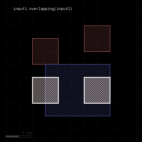 |
A range of counts can be specified. If so, the shape from the primary layer is only selected when overlapping a given number of shapes from the other layer. For the interpretation of the count see interacting.
"perimeter" - Returns the total perimeter of the polygons in the region
Usage:
- layer.perimeter
This method requires a polygon layer. It returns the total perimeter of all polygons in micron. Merged semantics applies, i.e. before computing the perimeter, the polygons are merged unless raw mode is chosen (see raw).
The returned value gives the perimeter in micrometer units.
"polygons" - Returns polygons from edge pairs
Usage:
- layer.polygons([ enlargement ])
This method applies to edge pair collections. The edge pairs will be converted into polygons connecting the edges the edge pairs are made of. In order to properly handle special edge pairs (coincident edges, point-like edges etc.) an enlargement parameter can be specified which will make the resulting polygon somewhat larger than the original edge pair. If the enlargement parameter is 0, special edge pairs with an area of 0 will be dropped.
"polygons?" - Returns true, if the layer is a polygon layer
Usage:
- layer.polygons?
"pull_inside" - Selects shapes or regions of other which are inside polygons from the this region
Usage:
- layer.pull_inside(other)
This method selects all shapes or regions from other which are inside polygons from this region. Unless other is in raw mode (see raw), coherent regions are selected from other, otherwise individual shapes are selected.
The functionality is similar to select_inside, but chosing shapes from other rather than from self. Because in deep mode the hierarchy reference comes from self, this method provides a way to pull shapes from other to the hierarchy to self.
This method is available for polygon layers. Other needs to be a polygon layer too.
"pull_interacting" - Selects shapes or edges of other which touch or overlap shapes from the this region
Usage:
- layer.pull_interacting(other)
This method selects all shapes or regions from other which touch or overlap shapes from this region. Unless other is in raw mode (see raw), coherent regions are selected from other, otherwise individual shapes are selected.
The functionality is similar to select_interacting, but chosing shapes from other rather than from self. Because in deep mode the hierarchy reference comes from self, this method provides a way to pull shapes from other to the hierarchy to self.
This method will neither modify self nor other.
This method is available for polygon, edge, edge pair and text layers, similar to interacting.
"pull_overlapping" - Selects shapes or regions of other which overlap shapes from the this region
Usage:
- layer.pull_overlapping(other)
This method selects all shapes or regions from other which overlap shapes from this region. Unless other is in raw mode (see raw), coherent regions are selected from other, otherwise individual shapes are selected.
The functionality is similar to select_overlapping, but chosing shapes from other rather than from self. Because in deep mode the hierarchy reference comes from self, this method provides a way to pull shapes from other to the hierarchy to self.
This method is available for polygon layers. Other needs to be a polygon layer too.
"raw" - Marks a layer as raw
Usage:
- layer.raw
A raw layer basically is the opposite of a "clean" layer (see clean). Polygons on a raw layer are considered "as is", i.e. overlapping polygons are not connected and inner edges may occur due to cut lines. Holes may not exists if the polygons are derived from a representation that does not allow holes (i.e. GDS2 files).
Note that this method will set the state of the layer. In combination with the fact, that copied layers are references to the original layer, this may lead to unexpected results:
l = ...
l2 = l1
... do something
l.raw
# now l2 is also a raw layer
To avoid that, use the dup method to create a real (deep) copy.
"rectangles" - Selects all rectangles from the input
Usage:
- layer.rectangles
This method is available for polygon layers. By default "merged" semantics applies, i.e. all polygons are merged before rectangles are selected (see clean and raw). non_rectangles will select all non-rectangles.
"rectilinear" - Selects all rectilinear polygons from the input
Usage:
- layer.rectilinear
This method is available for polygon layers. By default "merged" semantics applies, i.e. all polygons are merged before rectilinear polygons are selected (see clean and raw). non_rectilinear will select all non-rectangles.
"remove_props" - Returns a new layer with all properties removed
Usage:
- layer.remove_props
This method will drop all user properties from the layer. Note that a new layer without properties is returned. The original layer stays untouched.
See also select_props and map_props.
"rotate" - Rotates a layer (modifies the layer)
Usage:
- layer.rotate(a)
Rotates the input by the given angle (in degree). The layer that this method is called upon is modified and the modified version is returned for further processing.
"rotated" - Rotates a layer
Usage:
- layer.rotated(a)
Rotates the input layer by the given angle (in degree) and returns the rotated layer. The layer that this method is called upon is not modified.
The following image shows the effect of the "rotated" method:
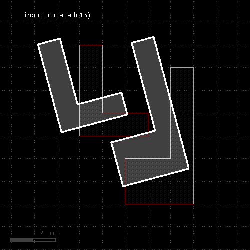 |
"rounded_corners" - Applies corner rounding to each corner of the polygon
Usage:
- layer.rounded_corners(inner, outer, n)
Inner (concave) corners are replaced by circle segments with a radius given by the "inner" parameter. Outer (convex) corners are relaced by circle segments with a radius given by the "outer" parameter.
The circles are approximated by polygons. "n" segments are used to approximate a full circle.
This method return a layer wit the modified polygons. Merged semantics applies for this method (see raw and clean). If used with tiling, the rounded_corners function may render invalid results because in tiling mode, not the whole merged region may be captured. In that case, inner edges may appear as outer ones and their corners will receive rounding.
The following image shows the effect of the "rounded_corners" method. The upper ends of the vertical bars are rounded with a smaller radius automatically because their width does not allow a larger radius.
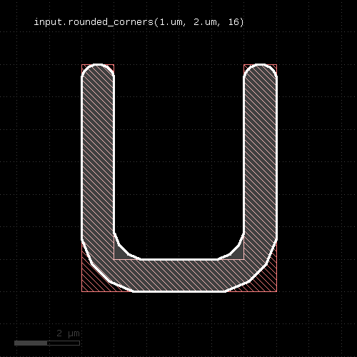 |
"scale" - Scales a layer (modifies the layer)
Usage:
- layer.scale(f)
Scales the input. After scaling, features have a f times bigger dimension. The layer that this method is called upon is modified and the modified version is returned for further processing.
"scaled" - Scales a layer
Usage:
- layer.scaled(f)
Scales the input layer and returns a new layer whose features have a f times bigger dimension. The layer that this method is called upon is not modified.
The following images shows the effect of the "scaled" method:
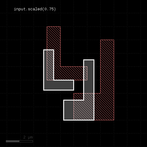 |
"second_edges" - Returns the second edges of an edge pair collection
Usage:
- layer.second_edges
Applies to edge pair collections only. Returns the second edges of the edge pairs in the collection.
Some checks deliver symmetric edge pairs (e.g. space, width, etc.) for which the edges are commutable. "second_edges" will not deliver edges for such edge pairs. Instead, "first_edges" will deliver both.
"select" - Selects edges, edge pairs or polygons based on evaluation of a block
Usage:
- layer.select { |object| ... }
This method evaluates the block and returns a new container with those objects for which the block evaluates to true. It is available for edge, polygon and edge pair layers. The corresponding objects are DPolygon, DEdge or DEdgePair.
Because this method executes inside the interpreter, it's inherently slow. Tiling does not apply to this method.
Here is a (slow) equivalent of the area selection method:
new_layer = layer.select { |polygon| polygon.area >= 10.0 }
"select_covering" - Selects shapes or regions of self which completely cover (enclose) one or more shapes from the other region
Usage:
- layer.select_covering(other)
- layer.select_covering(other, min_count)
- layer.select_covering(other, min_count, max_count)
- layer.select_covering(other, min_count .. max_count)
This method selects all shapes or regions from self which cover shapes from the other region. Unless self is in raw mode (see raw), coherent regions are selected from self, otherwise individual shapes are selected. It modifies self to contain the selected shapes. A version which does not modify self is covering.
This method is available for polygons only.
"select_if" - Selects shapes of a layer based on the evaluation of an expression
Usage:
- layer.select_if(expression [, variables])
Evaluates the given expression on the shapes of the layer. If the evaluation gives a 'true' value, the shape is selected. Otherwise it is discarded.
The expression is written in KLayout expression notation.
As input, the expressions will receive the (merged) shapes in micrometer units (e.g. DPolygon type) by calling the "shape" function.
Available functions are:
- "shape": the current shape in micrometer units
- "value(name)": the value of a property with name 'name' or nil if the current shape does not have a property with this name
Properties with well-formed names (e.g. "VALUE") are available as variables in the expressions as a shortcut.
The expressions require a hint whether they make use of anisotropic or scale-dependent properties. For example, the height of a box is an anisotropic property. If a check is made inside a rotated cell, the height transforms to a width and the check renders different results for the same cell, if the cell is placed rotated and non-rotated. The solution is cell variant formation which happens automatically when the "aniso" hint is present.
Similarly, if a check is made against physical dimensions, the check will have different results for cells placed with different magnifications. Such a check is not scale-invariant and needs to get a "scaled" hint.
By default it is assumed that the expressions are isotropic and scale invariant. You can mark an expression as anisotropic and/or scale dependent using the following expression modifiers:
# isotropic and scale invariant
layer.select_if("shape.holes > 0")

# anisotropic, but scale invariant
layer.select_if(aniso("shape.bbox.height/shape.bbox.width > 2"))

# isotropic, but not scale invariant
layer.select_if(scales("shape.area > 10.0"))

# anisotropic and not scale invariant
layer.select_if(aniso_and_scales("shape.bbox.width > 10.0"))
If you forget to specify this hint, the expression will use the local shape properties and fail to correctly produce the results in the presence of deep mode and rotated or magnified cell instances.
'variables' is a hash of arbitrary names and values. Each of these values becomes available as a variable in the expression. This eliminates the need to build expression strings with pasted value strings for passing external values.
The following example selects all shapes on the layer with an area less than 10 square micrometers:
layer.select(scales("shape.area < 10.0"))
Written with a variable as a threshold this becomes:
layer.select(scales("shape.area < thr"), { "thr" => 10.0 })
This version modifies the input layer. A version that returns a new layer with the selected shapes is selected_if.
"select_inside" - Selects edges, edge pairs or polygons of self which are inside edges or polygons from the other layer
Usage:
- layer.select_inside(other)
This method is the in-place version of inside - i.e. it modifies the layer instead of returning a new layer and leaving the original layer untouched.
"select_interacting" - Selects shapes or regions of self which touch or overlap shapes from the other region
Usage:
- layer.select_interacting(other)
- layer.select_interacting(other, min_count)
- layer.select_interacting(other, min_count, max_count)
- layer.select_interacting(other, min_count .. max_count)
This method selects all shapes or regions from self which touch or overlap shapes from the other layer. Unless self is in raw mode (see raw), coherent regions are selected from self, otherwise individual shapes are selected. It modifies self to contain the selected shapes. A version which does not modify self is interacting.
This method is available for polygon, text, edge and edge pair layers. Edges and edge pairs can be selected with respect to other edges or polygons. Texts can be selected with respect to polygons. Polygons can be selected with respect to edges, texts and other polygons.
If a single count is given, shapes from self are selected only if they do interact at least with the given number of (different) shapes from the other layer. If a min and max count is given, shapes from self are selected only if they interact with min_count or more, but a maximum of max_count different shapes from the other layer. Two polygons overlapping or touching at two locations are counted as single interactions.
"select_not_covering" - Selects shapes or regions of self which do not cover (enclose) one or more shapes from the other region
Usage:
- layer.select_not_covering(other)
- layer.select_not_covering(other, min_count)
- layer.select_not_covering(other, min_count, max_count)
- layer.select_not_covering(other, min_count .. max_count)
This method selects all shapes or regions from self which do not cover shapes from the other region. Unless self is in raw mode (see raw), coherent regions are selected from self, otherwise individual shapes are selected. It modifies self to contain the selected shapes. A version which does not modify self is not_covering.
This method is available for polygons only.
"select_not_inside" - Selects edges, edge pairs or polygons of self which are not inside edges or polygons from the other layer
Usage:
- layer.select_not_inside(other)
This method is the in-place version of inside - i.e. it modifies the layer instead of returning a new layer and leaving the original layer untouched.
"select_not_interacting" - Selects shapes or regions of self which do not touch or overlap shapes from the other region
Usage:
- layer.select_not_interacting(other)
- layer.select_not_interacting(other, min_count)
- layer.select_not_interacting(other, min_count, max_count)
- layer.select_not_interacting(other, min_count .. max_count)
This method selects all shapes or regions from self which do not touch or overlap shapes from the other layer. Unless self is in raw mode (see raw), coherent regions are selected from self, otherwise individual shapes are selected. It modifies self to contain the selected shapes. A version which does not modify self is not_interacting.
This method is available for polygon, text, edge and edge pair layers. Edges or edge pairs can be selected with respect to other edges or polygons. Texts can be selected with respect to polygons. Polygons can be selected with respect to edges, texts and other polygons.
If a single count is given, shapes from self are selected only if they interact with less than the given number of (different) shapes from the other layer. If a min and max count is given, shapes from self are selected only if they interact with less than min_count or more than max_count different shapes from the other layer. Two polygons overlapping or touching at two locations are counted as single interactions.
"select_not_outside" - Selects edges, edge pairs or polygons of self which are not outside edges or polygons from the other layer
Usage:
- layer.select_not_outside(other)
This method is the in-place version of outside - i.e. it modifies the layer instead of returning a new layer and leaving the original layer untouched.
"select_not_overlapping" - Selects shapes or regions of self which do not overlap shapes from the other region
Usage:
- layer.select_not_overlapping(other)
- layer.select_not_overlapping(other, min_count)
- layer.select_not_overlapping(other, min_count, max_count)
- layer.select_not_overlapping(other, min_count .. max_count)
This method selects all shapes or regions from self which do not overlap shapes from the other region. Unless self is in raw mode (see raw), coherent regions are selected from self, otherwise individual shapes are selected. It modifies self to contain the selected shapes. A version which does not modify self is not_overlapping.
This method is available for polygons only.
"select_outside" - Selects edges, edge pairs or polygons of self which are outside edges or polygons from the other layer
Usage:
- layer.select_outside(other)
This method is the in-place version of outside - i.e. it modifies the layer instead of returning a new layer and leaving the original layer untouched.
"select_overlapping" - Selects shapes or regions of self which overlap shapes from the other region
Usage:
- layer.select_overlapping(other)
- layer.select_overlapping(other, min_count)
- layer.select_overlapping(other, min_count, max_count)
- layer.select_overlapping(other, min_count .. max_count)
This method selects all shapes or regions from self which overlap shapes from the other region. Unless self is in raw mode (see raw), coherent regions are selected from self, otherwise individual shapes are selected. It modifies self to contain the selected shapes. A version which does not modify self is overlapping.
This method is available for polygons only.
"select_props" - Enables or selects properties from a property-annotated layer
Usage:
- layer.select_props(keys)
This method will select specific property keys from layers. It returns a new layer with the new properties. The original layer is not modified.
You can specify the user property keys (names) to use. As user properties in general are a set of key/value pairs and may carry multiple values under different keys, this feature can be handy to filter out a specific aspect. To get only the values from key 1 (integer), use:
layer1 = input(1, 0, enable_properties)
layer1_filtered = layer1.select_props(1)
To get the combined key 1 and 2 properties, use:
layer1 = input(1, 0, enable_properties)
layer1_filtered = layer1.select_props(1, 2)
Without any arguments, this method will remove all properties. Note that you can directly filter or map properties on input which is more efficient than first loading all and then selecting some properties. See DRCSource#input for details.
map_props is a way to change property keys and remove_props will entirely remove all user properties.
"selected_if" - Selects shapes based on the evaluation of an expression
Usage:
- layer.selected_if(expression [, variables])
This method is the out-of-place version of select_if. It takes the same arguments.
"sep" - An alias for "separation"
Usage:
- layer.sep(value [, options])
See separation for a description of that method
"separation" - A two-layer spacing check
Usage:
- layer.separation(other_layer, value [, options])
- layer.sep(other_layer, value [, options])
Note: "separation" and "sep" are available as operators for the "universal DRC" function drc within the DRC framework. These variants have more options and are more intuitive to use. See separation for more details.
This method performs a two-layer spacing check. Like space, this method can be applied to edge or polygon layers. Locations where edges of the layer are closer than the specified distance to the other layer are reported as edge pair error markers.
"sep" is the short form of this method.
In contrast to the space and related methods, locations where both layers touch are also reported. More specifically, the case of zero spacing will also trigger an error while for space it will not.
As for the other DRC methods, merged semantics applies.
Distance values can be given as floating-point values (in micron) or integer values (in database units). To explicitly specify the unit, use the unit denominators.
The following image shows the effect of the separation check (input1: red, input2: blue):
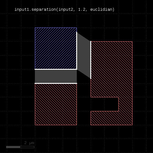 |
Touching shapes
Like width and space, the separation check also supports the "without_touching_corners" option.
This option will turn off errors that arise due to edges touching in one corner (the "kissing corners" configuration). By default, such edges will yield an error, as they form a zero-distance situation. With this option in place, no errors will be reported.
The following images illustrate the effect of the "without_touching_corners" option. The white line at the top of the bottom red shape is actually an edge pair indicating the zero-distance violation of the separation check:
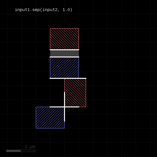 | 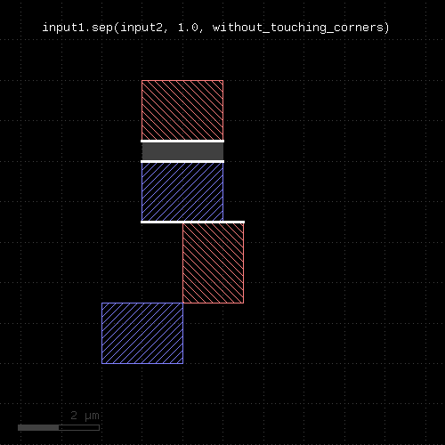 |
Another option is "without_touching_edges" which turns off errors that arise at coincident edges. Formally such edges represent a zero-distance situation, hence are flagged by default. Turning off the check in this case can be helpful when separating a layer into two parts (e.g. thin/wide metal separation) and an error between touching regions is not desired.
The "without_touching_edges" option is a stronger version of "without_touching_corners" and makes sense only for two-layer checks.
The following images illustrate the effect of the "without_touching_edges" option:
| 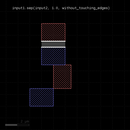 |
Opposite and rectangle error filtering
The options for the separation check are those available for the width or space method plus opposite and rectangle error filtering.
Opposite error filtering will waive errors that are on opposite sides of the original figure. The inverse is selection of errors only when there is an error present on the opposite side of the original figure. Opposite error waiving or selection is achieved through these options inside the DRC function call:
- not_opposite will waive opposite errors
- only_opposite will select errors only if there is an opposite one
These modes imply partial waiving or selection if "opposite" only applies to a section of an error.
The following images shows the effect of these options:
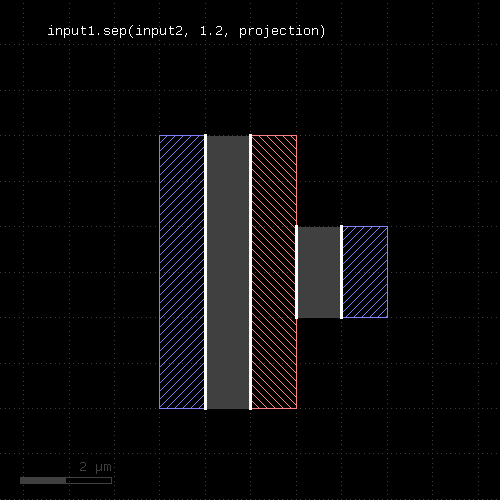 | |
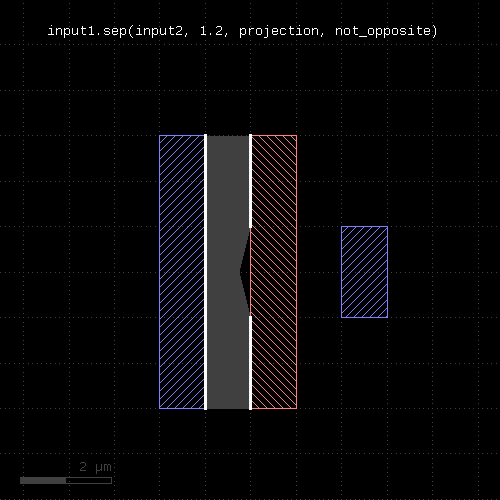 | 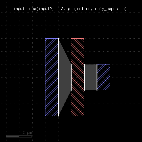 |
Rectangle error filtering allows waiving errors based on how they cover the sides of an original rectangular figure. This selection only applies to errors covering the full edge of the rectangle. Errors covering parts of the rectangle edges are not considered in this scheme.
The rectangle filter option is enabled by these modes:
- one_side_allowed will waive errors when they appear on one side of the rectangle only
- two_sides_allowed will waive errors when they appear on two sides of the rectangle
- two_connected_sides_allowed will waive errors when they appear on two connected sides of the rectangle ("L" configuration)
- two_opposite_sides_allowed will waive errors when they appear on two opposite sides of the rectangle
- three_sides_allowed will waive errors when they appear on three sides of the rectangle
- four_sides_allowed will waive errors when they appear on four sides of the rectangle
Multiple of these options can be given, which will make errors waived if one of these conditions is met.
The following images shows the effect of some rectangle filter modes:
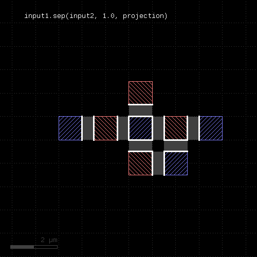 | |
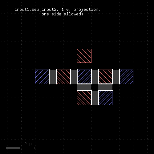 | 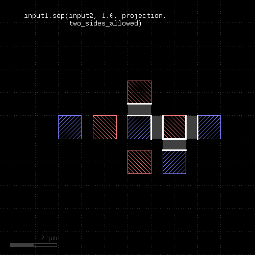 |
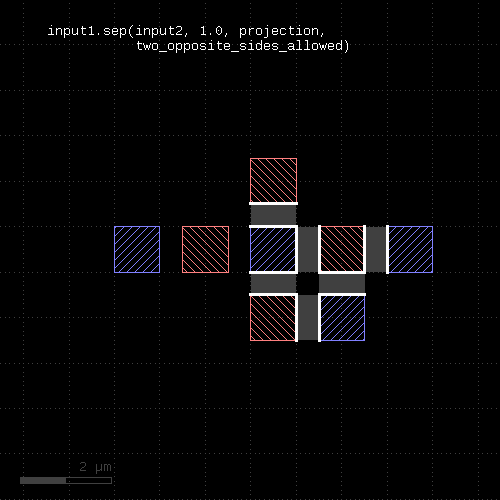 | 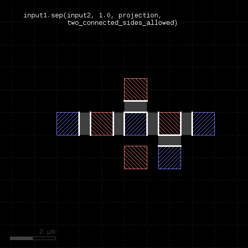 |
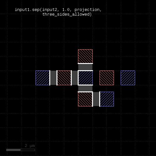 | 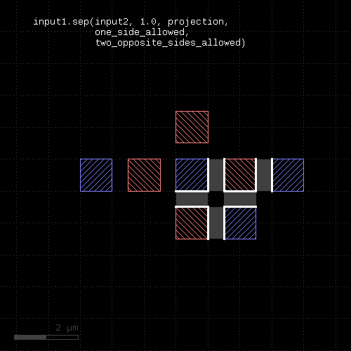 |
"size" - Polygon sizing (per-edge biasing, modifies the layer)
Usage:
- layer.size(d [, mode])
- layer.size(d, size_inside(l) [, steps(n)] [, mode])
- layer.size(d, size_outside(l) [, steps(n)] [, mode])
- layer.size(dx, dy [, mode])
- layer.size(dx, dy, size_inside(l) [, steps(n)] [, mode])
- layer.size(dx, dy, size_outside(l) [, steps(n)] [, mode])
See sized for a description of the options. The size method basically does the same but modifies the layer it is called on. The input layer is returned and available for further processing.
"sized" - Polygon sizing (per-edge biasing)
Usage:
- layer.sized(d [, mode] [, size_inside(l) [, steps(n)]])
- layer.sized(d, size_inside(l) [, steps(n)] [, mode])
- layer.sized(d, size_outside(l) [, steps(n)] [, mode])
- layer.sized(dx, dy [, mode])
- layer.sized(dx, dy, size_inside(l) [, steps(n)] [, mode])
- layer.sized(dx, dy, size_outside(l) [, steps(n)] [, mode])
This method requires a polygon layer. It will apply a bias per edge of the polygons and return the biased layer. The layer that this method is called on is not modified.
The alternative method size works like sized but modifies the layer it is called on.
In the single-value form, that bias is applied both in horizontal or vertical direction. In the two-value form, the horizontal and vertical bias can be specified separately.
The mode defines how to handle corners. The following modes are available:
- diamond_limit : This mode will connect the shifted edges without corner interpolation
- octagon_limit : This mode will create octagon-shaped corners
- square_limit : This mode will leave 90 degree corners untouched but cut off corners with a sharper angle. This is the default mode.
- acute_limit : This mode will leave 45 degree corners untouched but cut off corners with a sharper angle
- no_limit : This mode will not cut off (only at extremely sharp angles
Merged semantics applies, i.e. polygons will be merged before the sizing is applied unless the layer was put into raw mode (see raw). On output, the polygons are not merged immediately, so it is possible to detect overlapping regions after a positive sizing using raw and merged with an overlap count, for example:
layer.sized(300.nm).raw.merged(2)
Bias values can be given as floating-point values (in micron) or integer values (in database units). To explicitly specify the unit, use the unit denominators.
The following images show the effect of various forms of the "sized" method:
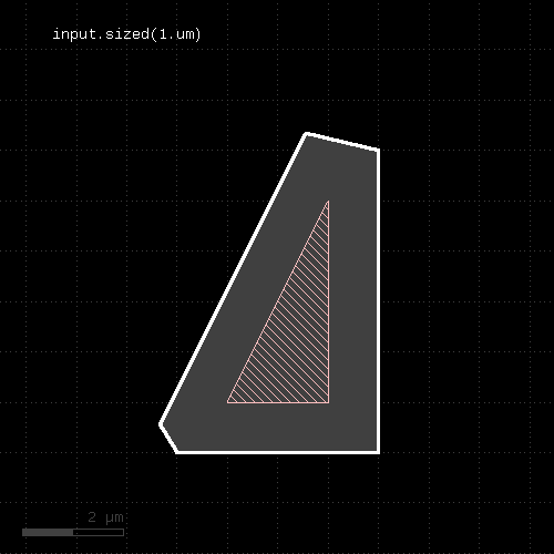 | 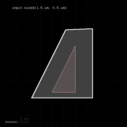 |
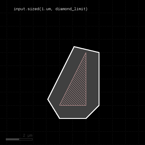 | 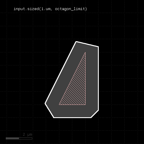 |
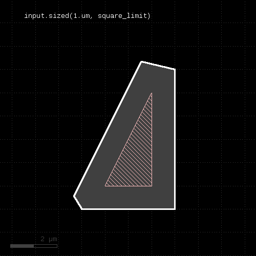 | 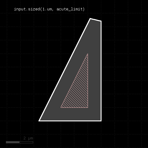 |
The "size_inside" option and the "steps" option implement incremental size. Incremental size means that the sizing value is applied in n steps. Between the steps, the sized shape is confined to the "size_inside" layer by means of a boolean "AND" operation.
This scheme is used to implement latch-up rules where a device active region has to be close to a well tap. By using the well layer as the "size_inside" layer, the size function follows the well contours. The steps have to selected such that the per-step size value is smaller than the minimum space of the well shapes. With that, the sized shapes will not cross over to neighbor well regions. Specifically, the per-step size has to be less than about 70% of the minimum space to account for the minimum corner-to-corner case with Euclidian space measurements.
"size_inside" and "steps" can be used with positive sizing values only. A steps value of 0 will not execute any sizing at all.
"size_outside" acts like "size_inside", but instead of confining the sized region to the inside of the given layer, it is confined to be outside of that layer. Technically, a boolean "NOT" is performed instead of a boolean "AND".
An example for the "size_inside" option is this:
ntap.sized(30.um, size_inside(nwell), steps(100))
The effect of the "size_inside" option is shown here:
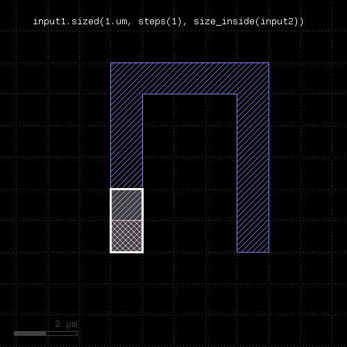 | 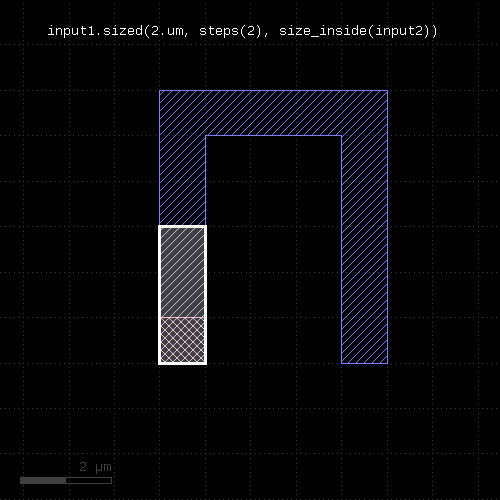 |
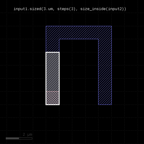 | 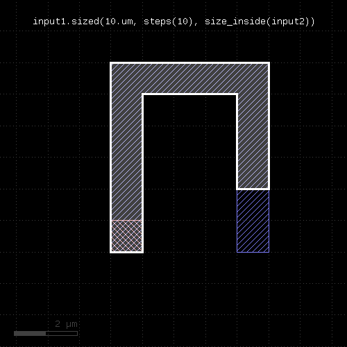 |
"smoothed" - Smoothes the polygons of the region
Usage:
- layer.smoothed(d)
- layer.smoothed(d, hv_keep)
"Smoothing" returns a simplified version of the polygons. Simplification is achieved by removing vertices unless the resulting polygon deviates by more than the given distance d from the original polygon.
"hv_keep" is a boolean parameter which makes the smoothing function maintain horizontal or vertical edges. The default is false, meaning horizontal or vertical edges may be changed into tilted ones.
This method return a layer wit the modified polygons. Merged semantics applies for this method (see raw and clean).
"snap" - Brings each vertex on the given grid (g or gx/gy for x or y direction)
Usage:
- layer.snap(g)
- layer.snap(gx, gy)
Shifts each off-grid vertex to the nearest on-grid location. If one grid is given, this grid is applied to x and y coordinates. If two grids are given, gx is applied to the x coordinates and gy is applied to the y coordinates. If 0 is given as a grid, no snapping is performed in that direction.
This method modifies the layer. A version that returns a snapped version of the layer without modifying the layer is snapped.
This method requires a polygon layer. Merged semantics applies (see raw and clean).
"snapped" - Returns a snapped version of the layer
Usage:
- layer.snapped(g)
- layer.snapped(gx, gy)
See snap for a description of the functionality. In contrast to snap, this method does not modify the layer but returns a snapped copy.
"space" - A space check
Usage:
- layer.space(value [, options])
Note: "space" is available as an operator for the "universal DRC" function Layer#drc within the DRC framework. This variant has more options and is more intuitive to use. See space for more details.
This method performs a space check and returns a collection of edge pairs. A space check can be performed on polygon and edge layers. On edge layers, all edges are checked against all other edges. If two edges form a "face to face" relation (i.e. their outer sides face each other) and their distance is less than the specified value, an error shape is generated for that edge pair. On polygon layers, the polygons on each layer are checked for space against other polygons for locations where their space is less than the specified value. In that case, an edge pair error shape is generated. The space check will also check the polygons for space violations against themselves, i.e. notches violating the space condition are reported.
The notch method is similar, but will only report self-space violations. The isolated method will only report space violations to other polygons. separation is a two-layer space check where space is checked against polygons of another layer.
As for the other DRC methods, merged semantics applies.
Distance values can be given as floating-point values (in micron) or integer values (in database units). To explicitly specify the unit, use the unit denominators.
For the manifold options of this function see the width method description.
The following image shows the effect of the space check:
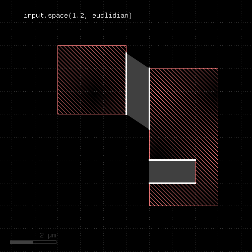 |
"split_covering" - Returns the results of covering and not_covering at the same time
Usage:
- (a, b) = layer.split_covering(other [, options ])
This method returns the polygons covering polygons from the other layer in one layer and all others in a second layer. This method is equivalent to calling covering and not_covering, but is faster than doing this in separate steps:
(covering, not_covering) = l1.split_covering(l2)
The options of this method are the same than covering.
"split_if" - Selects shapes based on the evaluation of an expression and returns selected and unselected shapes in different layers
Usage:
- layer.selected_if(expression [, variables])
This method, like the other 'split_...' methods returns two layers: one with the result of selected_if, and a second with all other shapes.
The following example splits a layer into two: one with the shapes that have an area less than 10 square micrometers and another one with the shapes that have a bigger area:
(smaller, bigger) = layer.split_if(scales("shape.area < 10.0"))
"split_inside" - Returns the results of inside and not_inside at the same time
Usage:
- (a, b) = layer.split_inside(other)
This method returns the polygons, edge pairs or edges inside of polygons or edges from the other layer in one layer and all others in a second layer. This method is equivalent to calling inside and not_inside, but is faster than doing this in separate steps:
(inside, not_inside) = l1.split_inside(l2)
"split_interacting" - Returns the results of interacting and not_interacting at the same time
Usage:
- (a, b) = layer.split_interacting(other [, options ])
This method returns the polygons or edges interacting with objects from the other container in one layer and all others in a second layer. This method is equivalent to calling interacting and not_interacting, but is faster than doing this in separate steps:
(interacting, not_interacting) = l1.split_interacting(l2)
The options of this method are the same than interacting.
"split_outside" - Returns the results of outside and not_outside at the same time
Usage:
- (a, b) = layer.split_outside(other)
This method returns the polygons, edge pairs or edges outside of polygons or edges from the other layer in one layer and all others in a second layer. This method is equivalent to calling outside and not_outside, but is faster than doing this in separate steps:
(outside, not_outside) = l1.split_outside(l2)
"split_overlapping" - Returns the results of overlapping and not_overlapping at the same time
Usage:
- (a, b) = layer.split_overlapping(other [, options ])
This method returns the polygons overlapping polygons from the other layer in one layer and all others in a second layer. This method is equivalent to calling overlapping and not_overlapping, but is faster than doing this in separate steps:
(overlapping, not_overlapping) = l1.split_overlapping(l2)
The options of this method are the same than overlapping.
"squares" - Selects all squares from the input
Usage:
- layer.squares
This method is available for polygon layers. By default "merged" semantics applies, i.e. all polygons are merged before squares are selected (see clean and raw). non_squares will select all non-rectangles.
"start_segments" - Returns the part at the beginning of each edge
Usage:
- layer.start_segments(length)
- layer.start_segments(length, fraction)
This method will return a partial edge for each edge in the input, located and the end of the original edge. The new edges will share the start point with the original edges, but not necessarily their end points. For further details about the orientation of edges and the parameters of this method, see end_segments.
The following images show the effect of the method:
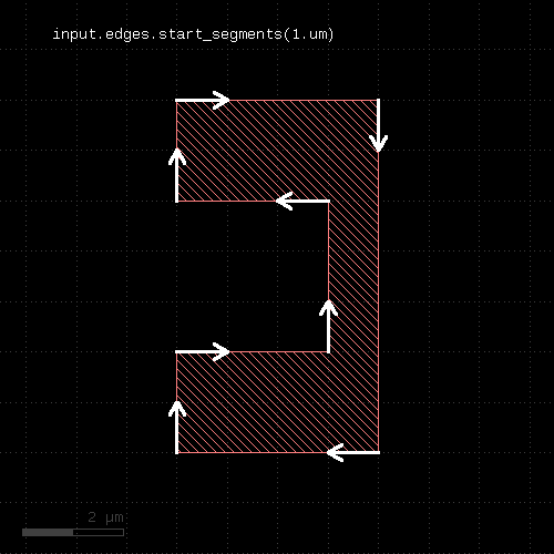 |  |
"strict" - Marks a layer for strict handling
Usage:
- layer.strict
If a layer is marked for strict handling, some optimizations are disabled. Specifically for boolean operations, the results will also be merged if one input is empty. For boolean operations, strict handling should be enabled for both inputs. Strict handling is disabled by default.
See non_strict about how to reset this mode.
This feature has been introduced in version 0.23.2.
"strict?" - Returns true, if strict handling is enabled for this layer
Usage:
- layer.is_strict?
See strict for a discussion of strict handling.
This feature has been introduced in version 0.23.2.
"texts" - Selects texts from an original layer
Usage:
- layer.texts
- layer.texts(p)
- layer.texts([ options ])
This method can be applied to original layers - i.e. ones that have been created with input. By default, a small box (2x2 DBU) will be produced on each selected text. By using the "as_dots" option, degenerated point-like edges will be produced.
The preferred method however is to use true text layers created with labels. In this case, without specifying "as_dots" or "as_boxes" retains the text objects as such a text filtering is applied. In contrast to this, layers generated with input cannot maintain the text nature of the selected objects and produce dots or small polygon boxes in the texts method.
Texts can be selected either by exact match string or a pattern match with a glob-style pattern. By default, glob-style pattern are used. The options available are:
- pattern(p) : Use a pattern to match the string (this is the default)
- text(s) : Select the texts that exactly match the given string
- as_boxes : with this option, small boxes will be produced as markers
- as_dots : with this option, point-like edges will be produced instead of small boxes
Here are some examples:
# Selects all texts
t = labels(1, 0).texts
# Selects all texts beginning with an "A"
t = labels(1, 0).texts("A*")
t = labels(1, 0).texts(pattern("A*"))
# Selects all texts whose string is "ABC"
t = labels(1, 0).texts(text("ABC"))
The effect of the operation is shown in these examples:
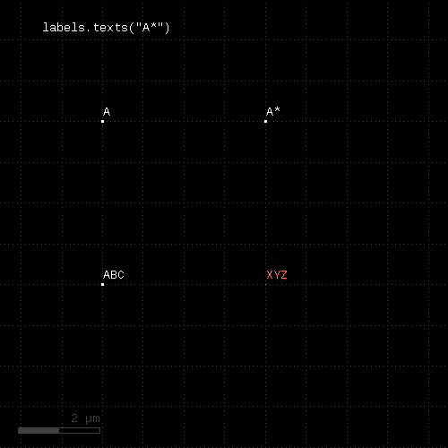 | 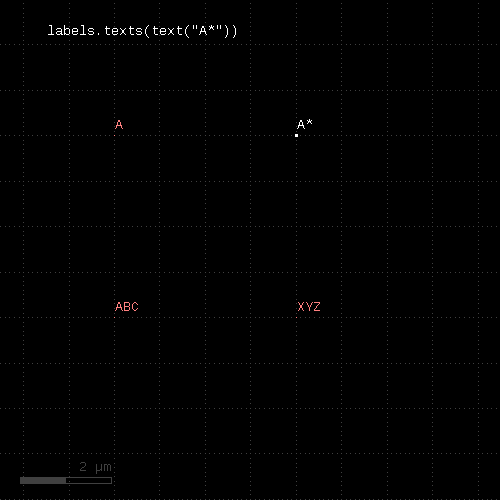 |
"texts?" - Returns true, if the layer is a text collection
Usage:
- layer.texts?
"texts_not" - Selects texts from an original layer not matching a specific selection
Usage:
- layer.texts_not
- layer.texts_not(p)
- layer.texts_not([ options ])
This method can be applied to true text layers obtained with labels. In this case, without specifying "as_dots" or "as_boxes" retains the text objects as such. Only text filtering is applied.
Beside that this method acts like texts, but will select the text objects not matching the filter.
"transform" - Transforms a layer (modifies the layer)
Usage:
- layer.transform(t)
Like transform, but modifies the input and returns a reference to it for further processing.
"transformed" - Transforms a layer
Usage:
- layer.transformed(t)
Transforms the input layer by the given transformation and returns the moved layer. The layer that this method is called upon is not modified. This is the most generic method is transform a layer. The transformation is a DCplxTrans object which describes many different kinds of affine transformations except shear and anisotropic magnification.
The following image shows the effect of the "moved" method:
|
"width" - A width check
Usage:
- layer.width(value [, options])
Note: "width" is available as an operator for the "universal DRC" function Layer#drc within the DRC framework. This variant has more options and is more intuitive to use. See width for more details.
This method performs a width check and returns a collection of edge pairs. A width check can be performed on polygon and edge layers. On edge layers, all edges are checked against all other edges. If two edges form a "back to back" relation (i.e. their inner sides face each other) and their distance is less than the specified value, an error shape is generated for that edge pair. On polygon layers, the polygons on each layer are checked for locations where their width is less than the specified value. In that case, an edge pair error shape is generated.
Options
The options available are:
- euclidian : perform the check using Euclidian metrics (this is the default)
- square : perform the check using Square metrics
- projection : perform the check using projection metrics
- whole_edges : With this option, the check will return all of the edges, even if the criterion is violated only over a part of the edge
- angle_limit(a) : Specifies the angle above or equal to which no check is performed. The default value is 90, which means that for edges having an angle of 90 degree or more, no check is performed. Setting this value to 45 will make the check only consider edges enclosing angles of less than 45 degree.
- projection_limits(min, max) or projection_limits(min .. max) : this option makes the check only consider edge pairs whose projected length on each other is more or equal than min and less than max
- projecting (in condition) : This specification is equivalent to "projection_limits" but is more intuitive, as "projecting" is written with a condition, like "projecting < 2.um". Available operators are: "==", "<", "<=", ">" and ">=". Double-bounded ranges are also available, like: "0.5 <= projecting < 2.0".
- without_touching_corners : With this option present, touching corners (aka "kissing corners") will not yield errors. The default is to produce errors in these cases.
- without_touching_edges : With this option present, coincident edges will not yield errors. This is a stronger version of "without_touching_corners" and makes sense only for two-layer checks or raw-mode input layers. It is listed here for completeness.
- transparent : Performs the check without shielding (polygon layers only)
- shielded : Performs the check with shielding (polygon layers only)
- props_eq , props_ne , props_copy : (only props_copy applies to width check) - See "Properties constraints" below.
Note that without the angle_limit, acute corners will always be reported, since two connected edges always violate the width in the corner. By adjusting the angle_limit, an acute corner check can be implemented.
Merge semantics applies to this method, i.e. disconnected polygons are merged before the width is checked unless "raw" mode is chosen.
The resulting edge pairs can be converted to polygons using the polygons method.
Distance values can be given as floating-point values (in micron) or integer values (in database units). To explicitly specify the unit, use the unit denominators, i.e.
# width check for 1.5 micron:
markers = in.width(1.5)
# width check for 2 database units:
markers = in.width(2)
# width check for 2 micron:
markers = in.width(2.um)
# width check for 20 nanometers:
markers = in.width(20.nm)
Examples
The following images show the effect of various forms of the width check:
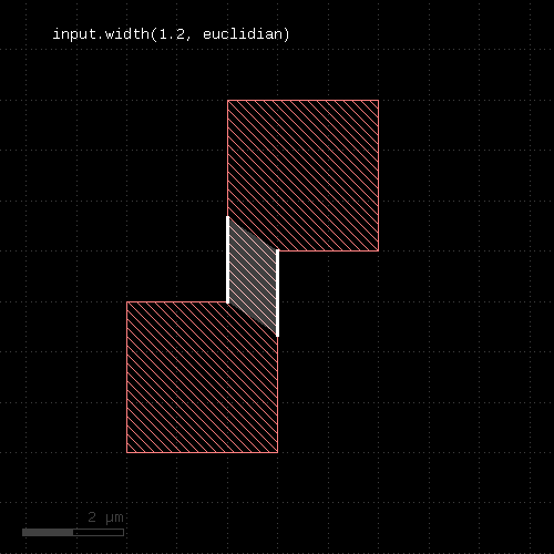 |  |
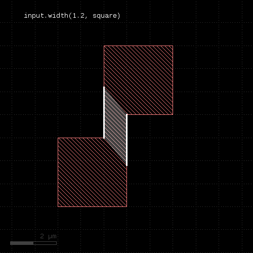 | 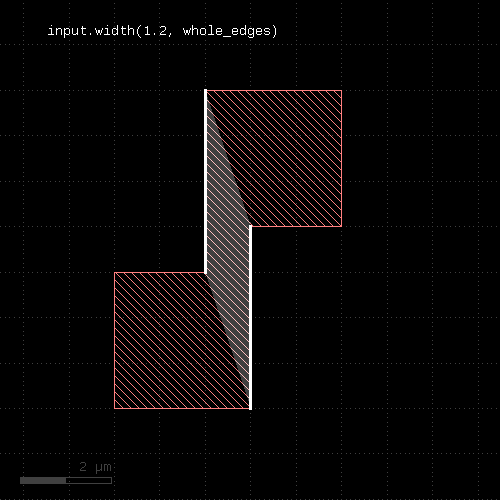 |
Universal DRC function
There is an alternative notation for the check using the "universal DRC" function ("Layer#drc"). This notation is more intuitive and allows checking for widths bigger than a certain value or within a certain range. See "width" for details.
Apart from that it provides the same options than the plain width check. Follow this link for the documentation of this feature: width.
Shielding
"shielding" is a concept where an internal or external distance is measured only if the opposite edge is not blocked by other edges between. Shielded mode makes a difference if very large distances are to be checked and the minimum distance is much smaller: in this case, a large distance violation may be blocked by features located between the edges which are checked. With shielding, large distance violations are not reported in this case. Shielding is also effective at zero distance which has an adverse effect: Consider a case, where one layer A is a subset of another layer B. If you try to check the distance between features of B vs. A, you cannot use shielding, because B features which are identical to A features will shield those entirely.
Shielding is enabled by default, but can be switched off with the "transparent" option.
Properties constraints (available on intra-polygon checks such as space, sep etc.)
This feature is listed here, because this documentation is generic and used for other checks as well. props_eq and props_ne are not available on 'width' or 'notch' as these apply to intra-polygon checks - when pairs of different polygons are involved - something that 'width' or 'notch' does need.
With properties constraints, the check is performed between shapes with the same or different properties. "properties" refers to the full set of key/value pairs attached to a shape.
Property constraints are specified by adding props_eq or props_ne to the arguments. If these literals are present, only shapes with same of different properties are involved in the check. In connection with the net annotation feature this allows checking space between connected or disconnected shapes for example:
connect(metal1, via1)
...

# attaches net identity as properties
metal1_nets = metal1.nets

space_not_connected = metal1_nets.space(0.4.um, props_ne)
space_connected     = metal1_nets.space(0.4.um, props_eq)
props_copy is a special properties constraint that does not alter the behaviour of the checks, but copies the primary shape's properties to the output markers. This constraint is applicable to width and notch checks too. The effect is that the original polygon's properties are copied to the error markers. props_copy can be combined with props_eq and props_ne to copy the original shape's properties to the output too:
space_not_connected = metal1_nets.space(0.4.um, props_ne + props_copy)
space_connected     = metal1_nets.space(0.4.um, props_eq + props_copy)
Touching shapes
The "without_touching_corners" option will turn off errors that arise due to the "kissing corner" configuration (or "checkerboard pattern"). Formally this is a width violation across the diagonal, but when considering this configuration as disconnected boxes, no error should be reported.
The following images illustrate the effect of the "without_touching_corners" option:
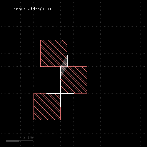 | 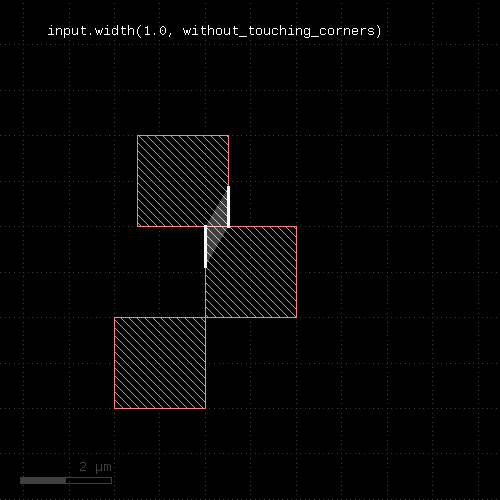 |
"with_angle" - Selects edges by their angle
Usage:
- layer.with_angle(min .. max [, absolute])
- layer.with_angle(value [, absolute])
- layer.with_angle(min, max [, absolute])
- layer.with_angle(ortho)
- layer.with_angle(diagonal)
- layer.with_angle(diagonal_only)
- edge_pair_layer.with_angle(... [, both] [, absolute])
When called on an edge layer, the method selects edges by their angle, measured against the horizontal axis in the mathematical sense.
For this measurement edges are considered without their direction and straight lines. A horizontal edge has an angle of zero degree. A vertical one has an angle of 90 degee. The angle range is from -90 (exclusive) to 90 degree (inclusive).
The first version of this method selects edges with a angle larger or equal to min and less than max (but not equal). The second version selects edges with exactly the given angle. The third version is identical to the first one.
When called on an edge pair layer, this method selects edge pairs with one or both edges meeting the angle criterion. In this case an additional argument is accepted which can be either "both" (plain word) to indicate that both edges have to be within the given interval. Without this argument, it is sufficient for one edge to meet the criterion.
The "absolute" option is available for edge or edge pair layers. Without the "absolute" option, edges sloping down are assigned a negative angle while edges sloping up are assigned a positive angle (vertical edges are always 90 degree). With the "absolute" option, edges sloping down also have a positive angle which is the one enclosed with the horizontal axis.
Here are examples for "with_angle" on edge pair layers:
# at least one edge needs to be horizontal
ep1 = edge_pairs.with_angle(0)
# both edges need to vertical
ep2 = edge_pairs.with_angle(90, both)
A method delivering all objects not matching the angle criterion is without_angle. Note that for edge pairs, in order to get the inverse result, you have to add or drop "both" on without_angle. This is because without_angle without both returns edge pairs where one edge does not match the criterion. The logical opposite of "one edge matches" however is "both edges do not match".
The following images demonstrate some use cases of with_angle and without_angle :
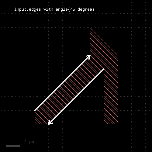 | 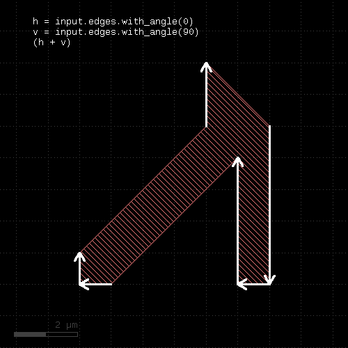 |
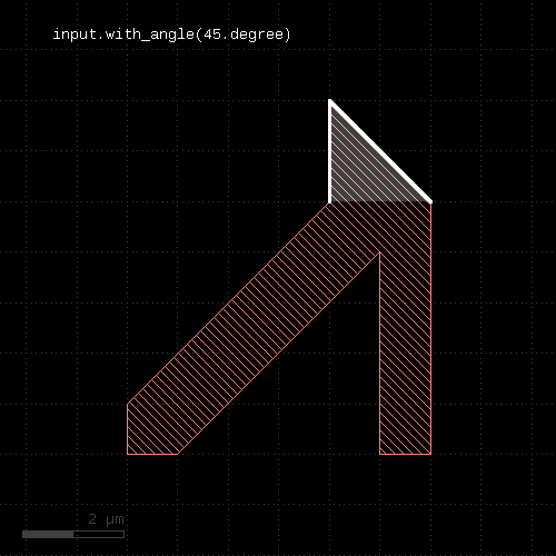 | 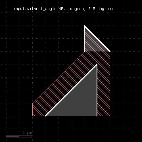 |
Specifying "ortho", "diagonal" or "diagonal_only" instead of the angle values will select 0 and 90 degree edges (ortho), -45 and 45 degree edges (diagonal_only) and both types (diagonal). This simplifies the implementation of selectors for manhattan or half-manhattan features:
ortho_edges = edges.with_angle(ortho)

# which is equivalent to, but more efficient as:
ortho_edges = edges.with_angle(0) + edges.with_angle(90)
Note that in former versions, with_angle could be used on polygon layers selecting corners with specific angles. This feature has been deprecated. Use corners instead.
"with_area" - Selects polygons or edge pairs by area
Usage:
- layer.with_area(min .. max)
- layer.with_area(value)
- layer.with_area(min, max)
The first form will select all polygons or edge pairs with an area larger or equal to min and less (but not equal to) max. The second form will select the polygons or edge pairs with exactly the given area. The third form basically is equivalent to the first form, but allows specification of nil for min or max indicating no lower or upper limit.
This method is available for polygon or edge pair layers.
"with_area_ratio" - Selects polygons by the ratio of the bounding box area vs. polygon area
Usage:
- layer.with_area_ratio(min .. max)
- layer.with_area_ratio(value)
- layer.with_area_ratio(min, max)
The area ratio is a measure how far a polygon is approximated by its bounding box. The value is always larger or equal to 1. Boxes have a area ratio of 1. Larger values mean more empty area inside the bounding box.
This method is available for polygon layers only.
"with_bbox_aspect_ratio" - Selects polygons by the aspect ratio of their bounding box
Usage:
- layer.with_bbox_aspect_ratio(min .. max)
- layer.with_bbox_aspect_ratio(value)
- layer.with_bbox_aspect_ratio(min, max)
The method selects polygons similar to with_area or with_perimeter. However, the measured value is the aspect ratio of the bounding box. It is the larger dimensions divided by the smaller one. The "thinner" the polygon, the larger the aspect ratio. A square bounding box gives an aspect ratio of 1.
This method is available for polygon layers only.
"with_bbox_height" - Selects polygons by the height of the bounding box
Usage:
- layer.with_bbox_height(min .. max)
- layer.with_bbox_height(value)
- layer.with_bbox_height(min, max)
The method selects polygons similar to with_area or with_perimeter. However, the measured dimension is the width of the bounding box.
This method is available for polygon layers only.
"with_bbox_max" - Selects polygons by the maximum dimension of the bounding box
Usage:
- layer.with_bbox_max(min .. max)
- layer.with_bbox_max(value)
- layer.with_bbox_max(min, max)
The method selects polygons similar to with_area or with_perimeter. However, the measured dimension is the maximum dimension of the bounding box. The maximum dimension is either the width or height of the bounding box, whichever is larger.
This method is available for polygon layers only.
"with_bbox_min" - Selects polygons by the minimum dimension of the bounding box
Usage:
- layer.with_bbox_min(min .. max)
- layer.with_bbox_min(value)
- layer.with_bbox_min(min, max)
The method selects polygons similar to with_area or with_perimeter. However, the measured dimension is the minimum dimension of the bounding box. The minimum dimension is either the width or height of the bounding box, whichever is smaller.
This method is available for polygon layers only.
"with_bbox_width" - Selects polygons by the width of the bounding box
Usage:
- layer.with_bbox_width(min .. max)
- layer.with_bbox_width(value)
- layer.with_bbox_width(min, max)
The method selects polygons similar to with_area or with_perimeter. However, the measured dimension is the width of the bounding box.
This method is available for polygon layers only.
"with_density" - Returns tiles whose density is within a given range
Usage:
- layer.with_density(min_value, max_value [, options ])
- layer.with_density(min_value .. max_value [, options ])
This method runs a tiled analysis over the current layout. It reports the tiles whose density is between "min_value" and "max_value". "min_value" and "max_value" are given in relative units, i.e. within the range of 0 to 1.0 corresponding to a density of 0 to 100%.
"min_value" or "max_value" can be nil or omitted in the ".." range notation. In this case, they are taken as "0" and "100%".
The tile size must be specified with the "tile_size" option:
# reports areas where layer 1/0 density is below 10% on 20x20 um tiles
low_density = input(1, 0).with_density(0.0 .. 0.1, tile_size(20.um))
Anisotropic tiles can be specified by giving two values, like "tile_size(10.um, 20.um)". The first value is the horizontal tile dimension, the second value is the vertical tile dimension.
A tile overlap can be specified using "tile_step". If the tile step is less than the tile size, the tiles will overlap. The layout window given by "tile_size" is moved in increments of the tile step:
# reports areas where layer 1/0 density is below 10% on 30x30 um tiles
# with a tile step of 20x20 um:
low_density = input(1, 0).with_density(0.0 .. 0.1, tile_size(30.um), tile_step(20.um))
For "tile_step", anisotropic values can be given as well by using two values: the first for the horizontal and the second for the vertical tile step.
Another option is "tile_origin" which specifies the location of the first tile's position. This is the lower left tile's lower left corner. If no origin is given, the tiles are centered over the area investigated.
By default, the tiles will cover the bounding box of the input layer. A separate layer can be used in addition. This way, the layout's dimensions can be derived from some drawn boundary layer. To specify a separate, additional layer included in the bounding box, use the "tile_boundary" option:
# reports density of layer 1/0 below 10% on 20x20 um tiles. The layout's boundary is taken from
# layer 0/0:
cell_frame = input(0, 0)
low_density = input(1, 0).with_density(0.0 .. 0.1, tile_size(20.um), tile_boundary(cell_frame))
Note that the layer given in "tile_boundary" adds to the input layer for computing the bounding box. The computed area is at least the area of the input layer.
Computation of the area can be skipped by explicitly giving a tile count in horizontal and vertical direction. With the "tile_origin" option this allows full control over the area covered:
# reports density of layer 1/0 below 10% on 20x20 um tiles in the region 0,0 .. 2000,3000
# (100 and 150 tiles of 20 um each are used in horizontal and vertical direction):
low_density = input(1, 0).with_density(0.0 .. 0.1, tile_size(20.um), tile_origin(0.0, 0.0), tile_count(100, 150))
The "padding mode" indicates how the area outside the layout's bounding box is considered. There are two modes:
- padding_zero : the outside area is considered zero density. This is the default mode.
- padding_ignore : the outside area is ignored for the density computation.
Example:
low_density = input(1, 0).with_density(0.0 .. 0.1, tile_size(20.um), padding_ignore)
The complementary version of "with_density" is without_density.
"with_distance" - Selects edge pairs by the distance of the edges
Usage:
- layer.with_distance(min .. max)
- layer.with_distance(value)
- layer.with_distance(min, max)
The method selects edge pairs by the distance of their edges. The first version selects edge pairs with a distance larger or equal to min and less than max (but not equal). The second version selects edge pairs with exactly the given distance. The third version is similar to the first one, but allows specification of nil for min or max indicating that there is no lower or upper limit.
The distance of the edges is defined by the minimum distance of all points from the edges involved. For edge pairs generated in geometrical checks this is equivalent to the actual distance of the original edges.
This method is available for edge pair layers only.
"with_holes" - Selects all polygons with the specified number of holes
Usage:
- layer.with_holes
- layer.with_holes(count)
- layer.with_holes(min_count, max_count)
- layer.with_holes(min_count .. max_count)
This method is available for polygon layers. It will select all polygons from the input layer which have the specified number of holes. Without any argument, all polygons with holes are selected.
"with_internal_angle" - Selects edge pairs by their internal angle
Usage:
- edge_pair_layer.with_internal_angle(min .. max)
- edge_pair_layer.with_internal_angle(value)
- edge_pair_layer.with_internal_angle(min, max)
This method selects edge pairs by the angle enclosed by their edges. The angle is between 0 (parallel or anti-parallel edges) and 90 degree (perpendicular edges). If an interval or two values are given, the angle is checked to be within the given range.
Here are examples for "with_internal_angle" on edge pair layers:
# selects edge pairs with parallel edges
ep1 = edge_pairs.with_internal_angle(0)
# selects edge pairs with perpendicular edges
ep2 = edge_pairs.with_internal_angle(90)
"with_length" - Selects edges by their length
Usage:
- layer.with_length(min .. max)
- layer.with_length(value)
- layer.with_length(min, max)
- edge_pairlayer.with_length(min, max [, both])
The method selects edges by their length. The first version selects edges with a length larger or equal to min and less than max (but not equal). The second version selects edges with exactly the given length. The third version is similar to the first one, but allows specification of nil for min or max indicating that there is no lower or upper limit.
This method is available for edge and edge pair layers.
When called on an edge pair layer, this method will select edge pairs if one or both of the edges meet the length criterion. Use the additional argument and pass "both" (plain word) to specify that both edges need to be within the given interval. By default, it's sufficient for one edge to meet the criterion.
Here are examples for "with_length" on edge pair layers:
# at least one edge needs to have a length of 1.0 <= l < 2.0
ep1 = edge_pairs.with_length(1.um .. 2.um)
# both edges need to have a length of exactly 2 um
ep2 = edge_pairs.with_length(2.um, both)
"with_perimeter" - Selects polygons by perimeter
Usage:
- layer.with_perimeter(min .. max)
- layer.with_perimeter(value)
- layer.with_perimeter(min, max)
The first form will select all polygons with an perimeter larger or equal to min and less (but not equal to) max. The second form will select the polygons with exactly the given perimeter. The third form basically is equivalent to the first form, but allows specification of nil for min or max indicating no lower or upper limit.
This method is available for polygon layers only.
"with_relative_height" - Selects polygons by the ratio of the height vs. width of its bounding box
Usage:
- layer.with_relative_height(min .. max)
- layer.with_relative_height(value)
- layer.with_relative_height(min, max)
The relative height is a measure how tall a polygon is. Tall polygons have values larger than 1, wide polygons have a value smaller than 1. Squares have a value of 1.
Don't use this method when you can use with_area_ratio, which provides a similar measure but is isotropic.
This method is available for polygon layers only.
"without_angle" - Selects edges by the their angle
Usage:
- layer.without_angle(min .. max [, absolute])
- layer.without_angle(value [, absolute])
- layer.without_angle(min, max [, absolute])
- layer.without_angle(ortho)
- layer.without_angle(diagonal)
- layer.without_angle(diagonal_only)
- edge_pair_layer.without_angle(... [, both] [, absolute])
The method basically is the inverse of with_angle. It selects all edges of the edge layer or corners of the polygons which do not have the given angle (second form) or whose angle is not inside the given interval (first and third form) or of the given type (other forms).
When called on edge pairs, it selects edge pairs by the angles of their edges.
The "absolute" option is available for edge or edge pair layers. Without the "absolute" option, edges sloping down are assigned a negative angle while edges sloping up are assigned a positive angle (vertical edges are always 90 degree). With the "absolute" option, edges sloping down also have a positive angle which is the one enclosed with the horizontal axis.
A note on the "both" modifier (without_angle called on edge pairs): "both" means that both edges need to be "without_angle". For example
# both edges are not horizontal or:
# the edge pair is skipped if one edge is horizontal
ep = edge_pairs.without_angle(0, both)
See with_internal_angle and without_internal_angle to select edge pairs by the angle between the edges.
"without_area" - Selects polygons or edge pairs by area
Usage:
- layer.without_area(min .. max)
- layer.without_area(value)
- layer.without_area(min, max)
This method is the inverse of "with_area". It will select polygons or edge pairs without an area equal to the given one or outside the given interval.
This method is available for polygon or edge pair layers.
"without_area_ratio" - Selects polygons by the aspect ratio of their bounding box
Usage:
- layer.without_area_ratio(min .. max)
- layer.without_area_ratio(value)
- layer.without_area_ratio(min, max)
The method provides the opposite filter for with_area_ratio.
This method is available for polygon layers only.
"without_bbox_height" - Selects polygons by the aspect ratio of their bounding box
Usage:
- layer.without_bbox_aspect_ratio(min .. max)
- layer.without_bbox_aspect_ratio(value)
- layer.without_bbox_aspect_ratio(min, max)
The method provides the opposite filter for with_bbox_aspect_ratio.
This method is available for polygon layers only.
"without_bbox_max" - Selects polygons by the maximum dimension of the bounding box
Usage:
- layer.without_bbox_max(min .. max)
- layer.without_bbox_max(value)
- layer.without_bbox_max(min, max)
The method selects polygons similar to without_area or without_perimeter. However, the measured dimension is the maximum dimension of the bounding box. The minimum dimension is either the width or height of the bounding box, whichever is larger.
This method is available for polygon layers only.
"without_bbox_min" - Selects polygons by the minimum dimension of the bounding box
Usage:
- layer.without_bbox_min(min .. max)
- layer.without_bbox_min(value)
- layer.without_bbox_min(min, max)
The method selects polygons similar to without_area or without_perimeter. However, the measured dimension is the minimum dimension of the bounding box. The minimum dimension is either the width or height of the bounding box, whichever is smaller.
This method is available for polygon layers only.
"without_bbox_width" - Selects polygons by the width of the bounding box
Usage:
- layer.without_bbox_width(min .. max)
- layer.without_bbox_width(value)
- layer.without_bbox_width(min, max)
The method selects polygons similar to without_area or without_perimeter. However, the measured dimension is the width of the bounding box.
This method is available for polygon layers only.
"without_density" - Returns tiles whose density is not within a given range
Usage:
- layer.without_density(min_value, max_value [, options ])
- layer.without_density(min_value .. max_value [, options ])
For details about the operations and the operation see with_density. This version will return the tiles where the density is not within the given range.
"without_distance" - Selects edge pairs by the distance of the edges
Usage:
- layer.without_distance(min .. max)
- layer.without_distance(value)
- layer.without_distance(min, max)
The method basically is the inverse of with_distance. It selects all edge pairs of the edge pair layer which do not have the given distance (second form) or are not inside the given interval (first and third form).
This method is available for edge pair layers only.
"without_holes" - Selects all polygons with the specified number of holes
Usage:
- layer.without_holes
- layer.without_holes(count)
- layer.without_holes(min_count, max_count)
- layer.without_holes(min_count .. max_count)
This method is available for polygon layers. It will select all polygons from the input layer which do not have the specified number of holes. Without any arguments, all polygons without holes are selected.
"without_internal_angle" - Selects edge pairs by their internal angle
Usage:
- edge_pair_layer.without_internal_angle(min .. max)
- edge_pair_layer.without_internal_angle(value)
- edge_pair_layer.without_internal_angle(min, max)
The method basically is the inverse of with_internal_angle. It selects all edge pairs by the angle enclosed by their edges, applying the opposite criterion than with_internal_angle.
"without_length" - Selects edges by the their length
Usage:
- layer.without_length(min .. max)
- layer.without_length(value)
- layer.without_length(min, max)
- edge_pairlayer.with_length(min, max [, both])
The method basically is the inverse of with_length. It selects all edges of the edge layer which do not have the given length (second form) or are not inside the given interval (first and third form).
This method is available for edge and edge pair layers.
A note on the "both" modifier (without_length called on edge pairs): "both" means that both edges need to be "without_length". For example
# both edges are not exactly 1 um in length, or:
# the edge pair is skipped if one edge has a length of exactly 1 um
ep = edge_pairs.without_length(1.um, both)
"without_perimeter" - Selects polygons by perimeter
Usage:
- layer.without_perimeter(min .. max)
- layer.without_perimeter(value)
- layer.without_perimeter(min, max)
This method is the inverse of "with_perimeter". It will select polygons without a perimeter equal to the given one or outside the given interval.
This method is available for polygon layers only.
"without_relative_height" - Selects polygons by the ratio of the height vs. width
Usage:
- layer.without_relative_height(min .. max)
- layer.without_relative_height(value)
- layer.without_relative_height(min, max)
The method provides the opposite filter for with_relative_height.
This method is available for polygon layers only.
"xor" - Boolean XOR operation
Usage:
- layer.xor(other)
The method computes a boolean XOR between self and other. It is an alias for the "^" operator.
This method is available for polygon and edge layers.
The following images show the effect of the "xor" method on polygons and edges (input1: red, input2: blue):
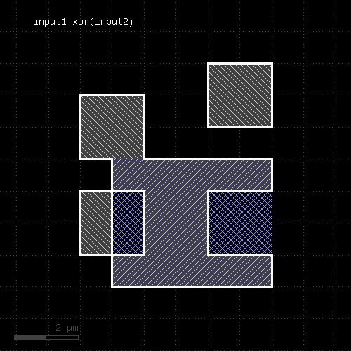 | 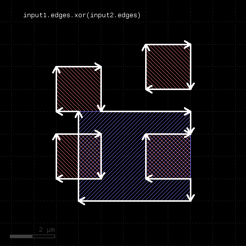 |
"|" - Boolean OR operation
Usage:
- self | other
The method computes a boolean OR between self and other. A similar operation is join which will basically gives the same result but won't merge the shapes.
This method is available for polygon and edge layers. An alias is "or". See there for a description of the function.